Horasan geodata
Horasan (Erzurum) is a seat of a second-order administrative division; located in Turkey in Europe/Istanbul (GMT+3) time zone. With population of 17,067 people, there are 364 cities with bigger population in this country. Compared to other cities in Turkey, 69.9% of cities are located further ↓South; 91.8% of cities are located further ←West and 92.5% of cities have lower elevation than Horasan. Note1


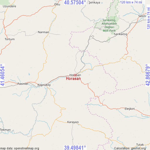
Horasan GPS coordinates[2]
40° 2' 19.86" North, 42° 9' 49.176" East
| Map corner | latitude | longitude |
|---|---|---|
| Upper-left | 40.57504°, | 41.46054° |
| Center: | 40.03885°, | 42.16366° |
| Lower-right: | 39.49841°, | 42.86679° |
| Map W x H: | 119.7×119.7 km | = 74.4×74.4mi |
| max Lat: | 42.02683° ⇑30.1% North |
| Horasan: | 40.03885° |
| min Lat: | ⇓69.9% South 35.9025° |
| min Long | Horasan | max Long |
| 25.90902° | 42.16366° | 44.60099° |
| W 91.8%⇐ | ⇒8.2% E |
Elevation
Elevation of Horasan is 1556 m = 5105 ft, and this is 838.6 m = 2751 ft above average elevation for this country.
| Max E: |
2682 m = 8799 ft | 7.5% |
| Horasan | 1556 m 5105 ft | |
| Avg. | 717.4 m = 2354 ft | |
Min E: |
0 m = 0 ft | 92.5% |
See also: Turkey elevation on elevation.city.
Geographical zone
Horasan is located in North temperate zone (between Tropic of Cancer and the Arctic Circle). Distance of this Northern Tropic circle is 1846 km =1147.1 mi to South.| Distance of | km | miles | from Horasan |
|---|---|---|---|
| North Pole | 5555.2 | 3451.8 | to North |
| Arctic Circle | 2949.3 | 1832.6 | to North |
| Tropic Cancer | 1846 | 1147.1 | to South |
| Equator | 4451.9 | 2766.3 | to South |


Nearby cities:
15 places around Horasan: (largest is in red/bold)
• Aras
13.4 km =8.3 mi,  114°
114°
• Eleşkirt
51.2 km =31.8 mi,  121°
121°
• Elmalıdere
46.6 km =29 mi,  163°
163°
• Gaziler
45.3 km =28.1 mi,  20°
20°
• Karakurt
40.1 km =24.9 mi,  69°
69°
• Karaurgan
24.2 km =15 mi, 22°
• Karayazı
38.2 km =23.7 mi,  182°
182°
• Köprüköy
26.4 km =16.4 mi,  252°
252°
• Kışlaköy
33.9 km =21.1 mi,  339°
339°
• Narman
42.6 km =26.5 mi,  322°
322°
• Pasinler
42.6 km =26.5 mi,  261°
261°
• Sarıkamış
48.2 km =30 mi,  48°
48°
• Söylemez
43.7 km =27.2 mi,  224°
224°
• Tahir
30.4 km =18.9 mi,  132°
132°
• Çiftlik
8.7 km =5.4 mi,  64°
64°
Sources, notices
• [Note1] Compared only with cities in Turkey existing in our database
• [Src1] Map data: © OpenStreetMap contributors (CC-BY-SA)
• [Src2] Other city data from geonames.org with taken over terms of usage.
• [Src3] Geographical zone / Annual Mean Temperature by Robert A. Rohde @ Wikipedia
