Göksu geodata
Göksu (Erzurum) is a seat of a third-order administrative division; located in Turkey in Europe/Istanbul (GMT+3) time zone. In our database, there are 1323 cities with bigger population. Compared to other cities in Turkey, 61% of cities are located further ↓South; 91.7% of cities are located further ←West and 97.7% of cities have lower elevation than Göksu. Note1


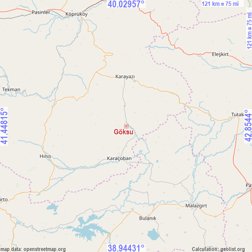
Göksu GPS coordinates[2]
39° 29' 20.616" North, 42° 9' 4.572" East
| Map corner | latitude | longitude |
|---|---|---|
| Upper-left | 40.02957°, | 41.44815° |
| Center: | 39.48906°, | 42.15127° |
| Lower-right: | 38.94431°, | 42.8544° |
| Map W x H: | 120.7×120.7 km | = 75×75mi |
| max Lat: | 42.02683° ⇑39% North |
| Göksu: | 39.48906° |
| min Lat: | ⇓61% South 35.9025° |
| min Long | Göksu | max Long |
| 25.90902° | 42.15127° | 44.60099° |
| W 91.7%⇐ | ⇒8.3% E |
Elevation
Elevation of Göksu is 1823 m = 5981 ft, and this is 1105.6 m = 3627 ft above average elevation for this country.
| Max E: |
2682 m = 8799 ft | 2.3% |
| Göksu | 1823 m 5981 ft | |
| Avg. | 717.4 m = 2354 ft | |
Min E: |
0 m = 0 ft | 97.7% |
See also: Turkey elevation on elevation.city.
Geographical zone
Göksu is located in North temperate zone (between Tropic of Cancer and the Arctic Circle). Distance of this Northern Tropic circle is 1784.9 km =1109.1 mi to South.| Distance of | km | miles | from Göksu |
|---|---|---|---|
| North Pole | 5616.3 | 3489.8 | to North |
| Arctic Circle | 3010.4 | 1870.6 | to North |
| Tropic Cancer | 1784.9 | 1109.1 | to South |
| Equator | 4390.8 | 2728.3 | to South |


Nearby cities:
15 places around Göksu: (largest is in red/bold)
• Aktuzla
21.1 km =13.1 mi,  146°
146°
• Bulanık
45.9 km =28.5 mi,  166°
166°
• Elmalıdere
21.9 km =13.6 mi,  41°
41°
• Halilçavuş
40.9 km =25.4 mi,  228°
228°
• Hınıs
42 km =26.1 mi,  249°
249°
• Karaağıl
39.7 km =24.7 mi,  188°
188°
• Karaköprü
25.1 km =15.6 mi,  219°
219°
• Karayazı
23 km =14.3 mi,  358°
358°
• Karaçoban
16.8 km =10.4 mi,  195°
195°
• Malazgirt
50.4 km =31.3 mi,  139°
139°
• Nurettin
36.9 km =22.9 mi, 141°
• Nurettin
38.4 km =23.9 mi,  127°
127°
• Söylemez
42.5 km =26.4 mi,  315°
315°
• Tahir
47.2 km =29.3 mi,  30°
30°
• Tutak
53 km =32.9 mi,  84°
84°
Sources, notices
• [Note1] Compared only with cities in Turkey existing in our database
• [Src1] Map data: © OpenStreetMap contributors (CC-BY-SA)
• [Src2] Other city data from geonames.org with taken over terms of usage.
• [Src3] Geographical zone / Annual Mean Temperature by Robert A. Rohde @ Wikipedia
