Karayazı geodata
Karayazı (Erzurum) is a seat of a second-order administrative division; located in Turkey in Europe/Istanbul (GMT+3) time zone. With population of 7,340 people, there are 602 cities with bigger population in this country. Compared to other cities in Turkey, 64.3% of cities are located further ↓South; 91.7% of cities are located further ←West and 99.9% of cities have lower elevation than Karayazı. Note1


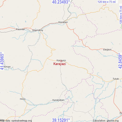
Karayazı GPS coordinates[2]
39° 41' 45.744" North, 42° 8' 33.972" East
| Map corner | latitude | longitude |
|---|---|---|
| Upper-left | 40.23493°, | 41.43965° |
| Center: | 39.69604°, | 42.14277° |
| Lower-right: | 39.15291°, | 42.8459° |
| Map W x H: | 120.3×120.3 km | = 74.8×74.8mi |
| max Lat: | 42.02683° ⇑35.7% North |
| Karayazı: | 39.69604° |
| min Lat: | ⇓64.3% South 35.9025° |
| min Long | Karayazı | max Long |
| 25.90902° | 42.14277° | 44.60099° |
| W 91.7%⇐ | ⇒8.3% E |
Elevation
Elevation of Karayazı is 2260 m = 7415 ft, and this is 1542.6 m = 5061 ft above average elevation for this country.
| Max E: |
2682 m = 8799 ft | 0.099999999999994% |
| Karayazı | 2260 m 7415 ft | |
| Avg. | 717.4 m = 2354 ft | |
Min E: |
0 m = 0 ft | 99.9% |
See also: Turkey elevation on elevation.city.
Geographical zone
Karayazı is located in North temperate zone (between Tropic of Cancer and the Arctic Circle). Distance of this Northern Tropic circle is 1807.9 km =1123.4 mi to South.| Distance of | km | miles | from Karayazı |
|---|---|---|---|
| North Pole | 5593.3 | 3475.5 | to North |
| Arctic Circle | 2987.4 | 1856.3 | to North |
| Tropic Cancer | 1807.9 | 1123.4 | to South |
| Equator | 4413.8 | 2742.6 | to South |


Nearby cities:
15 places around Karayazı: (largest is in red/bold)
• Aktuzla
42.5 km =26.4 mi,  163°
163°
• Aras
35.4 km =22 mi,  23°
23°
• Eleşkirt
47 km =29.2 mi,  76°
76°
• Elmalıdere
16.5 km =10.3 mi,  113°
113°
• Göksu
23 km =14.3 mi,  178°
178°
• Horasan
38.2 km =23.7 mi,  2°
2°
• Hınıs
53.9 km =33.5 mi,  225°
225°
• Karaköprü
45 km =28 mi,  199°
199°
• Karaçoban
39.4 km =24.5 mi,  185°
185°
• Köprüköy
38.1 km =23.7 mi,  322°
322°
• Pasinler
51.2 km =31.8 mi,  308°
308°
• Söylemez
30 km =18.6 mi,  283°
283°
• Tahir
30.2 km =18.8 mi,  53°
53°
• Tekman
54.9 km =34.1 mi,  263°
263°
• Çiftlik
42.9 km =26.7 mi,  13°
13°
Sources, notices
• [Note1] Compared only with cities in Turkey existing in our database
• [Src1] Map data: © OpenStreetMap contributors (CC-BY-SA)
• [Src2] Other city data from geonames.org with taken over terms of usage.
• [Src3] Geographical zone / Annual Mean Temperature by Robert A. Rohde @ Wikipedia
