Tahir geodata
Tahir (Ağrı) is a seat of a third-order administrative division; located in Turkey in Europe/Istanbul (GMT+3) time zone. In our database, there are 1323 cities with bigger population. Compared to other cities in Turkey, 66.6% of cities are located further ↓South; 93.6% of cities are located further ←West and 99.7% of cities have lower elevation than Tahir. Note1


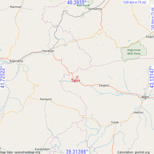
Tahir GPS coordinates[2]
39° 51' 21.096" North, 42° 25' 42.024" East
| Map corner | latitude | longitude |
|---|---|---|
| Upper-left | 40.3935°, | 41.72522° |
| Center: | 39.85586°, | 42.42834° |
| Lower-right: | 39.31398°, | 43.13147° |
| Map W x H: | 120×120 km | = 74.6×74.6mi |
| max Lat: | 42.02683° ⇑33.4% North |
| Tahir: | 39.85586° |
| min Lat: | ⇓66.6% South 35.9025° |
| min Long | Tahir | max Long |
| 25.90902° | 42.42834° | 44.60099° |
| W 93.6%⇐ | ⇒6.4% E |
Elevation
Elevation of Tahir is 2129 m = 6985 ft, and this is 1411.6 m = 4631 ft above average elevation for this country.
| Max E: |
2682 m = 8799 ft | 0.3% |
| Tahir | 2129 m 6985 ft | |
| Avg. | 717.4 m = 2354 ft | |
Min E: |
0 m = 0 ft | 99.7% |
See also: Turkey elevation on elevation.city.
Geographical zone
Tahir is located in North temperate zone (between Tropic of Cancer and the Arctic Circle). Distance of this Northern Tropic circle is 1825.6 km =1134.4 mi to South.| Distance of | km | miles | from Tahir |
|---|---|---|---|
| North Pole | 5575.5 | 3464.5 | to North |
| Arctic Circle | 2969.6 | 1845.2 | to North |
| Tropic Cancer | 1825.6 | 1134.4 | to South |
| Equator | 4431.6 | 2753.7 | to South |


Nearby cities:
15 places around Tahir: (largest is in red/bold)
• Aras
18 km =11.2 mi,  324°
324°
• Ağrı
55.4 km =34.4 mi,  105°
105°
• Eleşkirt
22.1 km =13.7 mi, 106°
• Elmalıdere
26 km =16.2 mi,  200°
200°
• Göksu
47.2 km =29.3 mi,  210°
210°
• Hamur
55.1 km =34.2 mi,  120°
120°
• Horasan
30.4 km =18.9 mi,  312°
312°
• Karakurt
37.6 km =23.4 mi,  23°
23°
• Karaurgan
44.7 km =27.8 mi,  342°
342°
• Karayazı
30.2 km =18.8 mi,  233°
233°
• Köprüköy
49.3 km =30.6 mi,  284°
284°
• Sarıkamış
54.2 km =33.7 mi,  14°
14°
• Söylemez
54.6 km =33.9 mi,  258°
258°
• Tutak
45.6 km =28.3 mi,  140°
140°
• Çiftlik
28.2 km =17.5 mi,  328°
328°
Sources, notices
• [Note1] Compared only with cities in Turkey existing in our database
• [Src1] Map data: © OpenStreetMap contributors (CC-BY-SA)
• [Src2] Other city data from geonames.org with taken over terms of usage.
• [Src3] Geographical zone / Annual Mean Temperature by Robert A. Rohde @ Wikipedia
