Kumçatı geodata
Kumçatı (Şırnak) is a populated place; located in Turkey in Europe/Istanbul (GMT+3) time zone. With population of 5,005 people, there are 725 cities with bigger population in this country. Compared to other cities in Turkey, 75.7% of cities are located further ↑North; 92.6% of cities are located further ←West and 59.6% of cities have higher elevation than Kumçatı. Note1


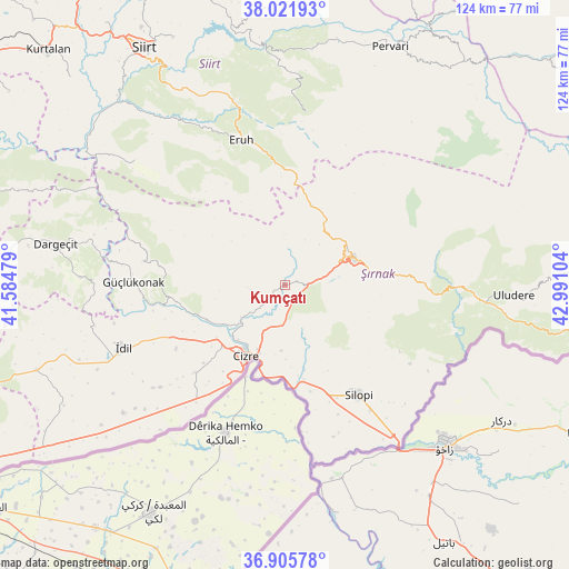
Kumçatı GPS coordinates[2]
37° 27' 57.384" North, 42° 17' 16.476" East
| Map corner | latitude | longitude |
|---|---|---|
| Upper-left | 38.02193°, | 41.58479° |
| Center: | 37.46594°, | 42.28791° |
| Lower-right: | 36.90578°, | 42.99104° |
| Map W x H: | 124.1×124.1 km | = 77.1×77.1mi |
| max Lat: | 42.02683° ⇑75.7% North |
| Kumçatı: | 37.46594° |
| min Lat: | ⇓24.3% South 35.9025° |
| min Long | Kumçatı | max Long |
| 25.90902° | 42.28791° | 44.60099° |
| W 92.6%⇐ | ⇒7.4% E |
Elevation
Elevation of Kumçatı is 514 m = 1686 ft, and this is 203.4 m = 667 ft below average elevation for this country.
| Max E: |
2682 m = 8799 ft | 59.6% |
| Avg. | 717.4 m = 2354 ft | |
| Kumçatı | 514 m = 1686 ft | |
Min E: |
0 m = 0 ft | 40.4% |
See also: Turkey elevation on elevation.city.
Geographical zone
Kumçatı is located in North temperate zone (between Tropic of Cancer and the Arctic Circle). Distance of this Northern Tropic circle is 1559.9 km =969.3 mi to South.| Distance of | km | miles | from Kumçatı |
|---|---|---|---|
| North Pole | 5841.2 | 3629.6 | to North |
| Arctic Circle | 3235.4 | 2010.4 | to North |
| Tropic Cancer | 1559.9 | 969.3 | to South |
| Equator | 4165.8 | 2588.5 | to South |


Nearby cities:
15 places around Kumçatı: (largest is in red/bold)
• Balveren
23.1 km =14.4 mi,  85°
85°
• Bozalan
15.4 km =9.6 mi,  187°
187°
• Cizre
17.6 km =10.9 mi,  211°
211°
• Doruklu
23.8 km =14.8 mi,  169°
169°
• Düzova
21.6 km =13.4 mi,  234°
234°
• Geçitboyu
20.6 km =12.8 mi,  81°
81°
• Kayaboyun
16.3 km =10.1 mi,  273°
273°
• Kızılsu
8.2 km =5.1 mi,  260°
260°
• Razvaliny Ayinvan
21.1 km =13.1 mi, 168°
• Serhatta
25.4 km =15.8 mi,  329°
329°
• Sulak
23.3 km =14.5 mi,  215°
215°
• Tililan
24.6 km =15.3 mi,  245°
245°
• Yeniköy
24.8 km =15.4 mi,  150°
150°
• Yeşilyurt
22 km =13.7 mi, 216°
• Şırnak
15.6 km =9.7 mi,  70°
70°
Sources, notices
• [Note1] Compared only with cities in Turkey existing in our database
• [Src1] Map data: © OpenStreetMap contributors (CC-BY-SA)
• [Src2] Other city data from geonames.org with taken over terms of usage.
• [Src3] Geographical zone / Annual Mean Temperature by Robert A. Rohde @ Wikipedia
