Geçitboyu geodata
Geçitboyu (Şırnak) is a populated place; located in Turkey in Europe/Istanbul (GMT+3) time zone. With population of 778 people, there are 1164 cities with bigger population in this country. Compared to other cities in Turkey, 74.9% of cities are located further ↑North; 94.3% of cities are located further ←West and 88.8% of cities have lower elevation than Geçitboyu. Note1


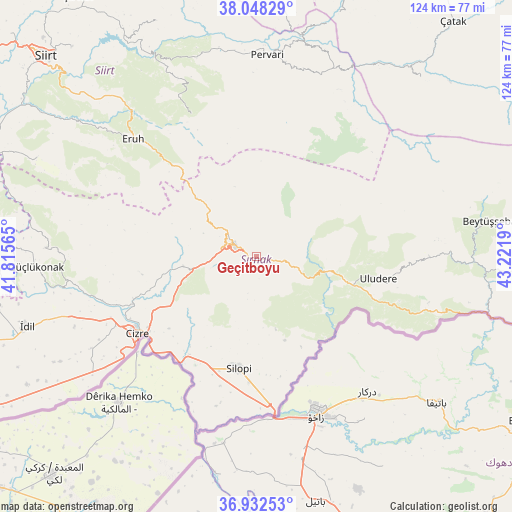
Geçitboyu GPS coordinates[2]
37° 29' 32.964" North, 42° 31' 7.572" East
| Map corner | latitude | longitude |
|---|---|---|
| Upper-left | 38.04829°, | 41.81565° |
| Center: | 37.49249°, | 42.51877° |
| Lower-right: | 36.93253°, | 43.2219° |
| Map W x H: | 124.1×124.1 km | = 77.1×77.1mi |
| max Lat: | 42.02683° ⇑74.9% North |
| Geçitboyu: | 37.49249° |
| min Lat: | ⇓25.1% South 35.9025° |
| min Long | Geçitboyu | max Long |
| 25.90902° | 42.51877° | 44.60099° |
| W 94.3%⇐ | ⇒5.7% E |
Elevation
Elevation of Geçitboyu is 1425 m = 4675 ft, and this is 707.6 m = 2322 ft above average elevation for this country.
| Max E: |
2682 m = 8799 ft | 11.2% |
| Geçitboyu | 1425 m 4675 ft | |
| Avg. | 717.4 m = 2354 ft | |
Min E: |
0 m = 0 ft | 88.8% |
See also: Turkey elevation on elevation.city.
Geographical zone
Geçitboyu is located in North temperate zone (between Tropic of Cancer and the Arctic Circle). Distance of this Northern Tropic circle is 1562.9 km =971.1 mi to South.| Distance of | km | miles | from Geçitboyu |
|---|---|---|---|
| North Pole | 5838.3 | 3627.8 | to North |
| Arctic Circle | 3232.4 | 2008.5 | to North |
| Tropic Cancer | 1562.9 | 971.1 | to South |
| Equator | 4168.8 | 2590.4 | to South |


Nearby cities:
15 places around Geçitboyu: (largest is in red/bold)
• Ballı
29.6 km =18.4 mi,  107°
107°
• Balveren
2.8 km =1.7 mi, 110°
• Bağlıca
23.5 km =14.6 mi, 106°
• Bisbin
17.6 km =10.9 mi,  165°
165°
• Bozalan
29 km =18 mi,  231°
231°
• Hilal
23.6 km =14.7 mi,  94°
94°
• Kumçatı
20.6 km =12.8 mi,  261°
261°
• Kızılsu
28.8 km =17.9 mi, 261°
• Okçular
28.5 km =17.7 mi,  346°
346°
• Razvaliny Ayinvan
28.7 km =17.8 mi,  214°
214°
• Silopi
28.1 km =17.5 mi,  190°
190°
• Yeniköy
26 km =16.2 mi,  198°
198°
• Çalışkan
24.3 km =15.1 mi,  153°
153°
• Şenoba
18.2 km =11.3 mi,  99°
99°
• Şırnak
6.2 km =3.9 mi,  292°
292°
Sources, notices
• [Note1] Compared only with cities in Turkey existing in our database
• [Src1] Map data: © OpenStreetMap contributors (CC-BY-SA)
• [Src2] Other city data from geonames.org with taken over terms of usage.
• [Src3] Geographical zone / Annual Mean Temperature by Robert A. Rohde @ Wikipedia
