Kayapınar geodata
Kayapınar (Diyarbakır) is a seat of a second-order administrative division; located in Turkey in Europe/Istanbul (GMT+3) time zone. In our database, there are 1323 cities with bigger population. Compared to other cities in Turkey, 63.3% of cities are located further ↑North; 74.8% of cities are located further ←West and 51.6% of cities have lower elevation than Kayapınar. Note1


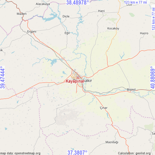
Kayapınar GPS coordinates[2]
37° 56' 14.388" North, 40° 10' 39.216" East
| Map corner | latitude | longitude |
|---|---|---|
| Upper-left | 38.48978°, | 39.47444° |
| Center: | 37.93733°, | 40.17756° |
| Lower-right: | 37.3807°, | 40.88069° |
| Map W x H: | 123.3×123.3 km | = 76.6×76.6mi |
| max Lat: | 42.02683° ⇑63.3% North |
| Kayapınar: | 37.93733° |
| min Lat: | ⇓36.7% South 35.9025° |
| min Long | Kayapınar | max Long |
| 25.90902° | 40.17756° | 44.60099° |
| W 74.8%⇐ | ⇒25.2% E |
Elevation
Elevation of Kayapınar is 728 m = 2388 ft, and this is 10.6 m = 35 ft above average elevation for this country.
| Max E: |
2682 m = 8799 ft | 48.4% |
| Kayapınar | 728 m 2388 ft | |
| Avg. | 717.4 m = 2354 ft | |
Min E: |
0 m = 0 ft | 51.6% |
See also: Turkey elevation on elevation.city.
Geographical zone
Kayapınar is located in North temperate zone (between Tropic of Cancer and the Arctic Circle). Distance of this Northern Tropic circle is 1612.3 km =1001.8 mi to South.| Distance of | km | miles | from Kayapınar |
|---|---|---|---|
| North Pole | 5788.8 | 3597 | to North |
| Arctic Circle | 3182.9 | 1977.8 | to North |
| Tropic Cancer | 1612.3 | 1001.8 | to South |
| Equator | 4218.2 | 2621.1 | to South |


Nearby cities:
15 places around Kayapınar: (largest is in red/bold)
• Ahmetli
38.8 km =24.1 mi,  313°
313°
• Ambar
32.1 km =19.9 mi,  106°
106°
• Bağlar
3.6 km =2.2 mi,  136°
136°
• Diyarbakır
4.4 km =2.7 mi,  127°
127°
• Eğil
36.7 km =22.8 mi,  345°
345°
• Kazancı
41.4 km =25.7 mi,  116°
116°
• Kerh
34.5 km =21.4 mi, 111°
• Köseli
39.3 km =24.4 mi, 106°
• Mermer
31.1 km =19.3 mi,  49°
49°
• Ovabağ
30.5 km =19 mi,  213°
213°
• Sur
5.2 km =3.2 mi, 120°
• Türkmenhacı
40.7 km =25.3 mi, 110°
• Yenişehir
3.5 km =2.2 mi,  277°
277°
• Yolboyu
16.1 km =10 mi,  254°
254°
• Çınar
31.3 km =19.4 mi, 139°
Sources, notices
• [Note1] Compared only with cities in Turkey existing in our database
• [Src1] Map data: © OpenStreetMap contributors (CC-BY-SA)
• [Src2] Other city data from geonames.org with taken over terms of usage.
• [Src3] Geographical zone / Annual Mean Temperature by Robert A. Rohde @ Wikipedia
