Eğil geodata
Eğil (Diyarbakır) is a seat of a second-order administrative division; located in Turkey in Europe/Istanbul (GMT+3) time zone. With population of 4,820 people, there are 737 cities with bigger population in this country. Compared to other cities in Turkey, 57% of cities are located further ↑North; 74% of cities are located further ←West and 58.8% of cities have lower elevation than Eğil. Note1


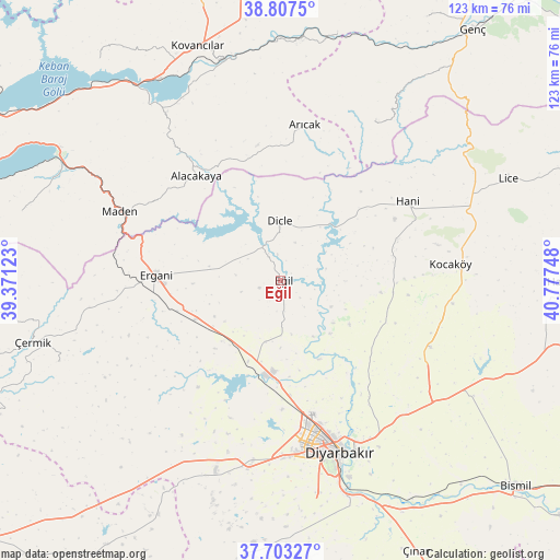
Eğil GPS coordinates[2]
38° 15' 26.928" North, 40° 4' 27.66" East
| Map corner | latitude | longitude |
|---|---|---|
| Upper-left | 38.8075°, | 39.37123° |
| Center: | 38.25748°, | 40.07435° |
| Lower-right: | 37.70327°, | 40.77748° |
| Map W x H: | 122.8×122.8 km | = 76.3×76.3mi |
| max Lat: | 42.02683° ⇑57% North |
| Eğil: | 38.25748° |
| min Lat: | ⇓43% South 35.9025° |
| min Long | Eğil | max Long |
| 25.90902° | 40.07435° | 44.60099° |
| W 74%⇐ | ⇒26% E |
Elevation
Elevation of Eğil is 861 m = 2825 ft, and this is 143.6 m = 471 ft above average elevation for this country.
| Max E: |
2682 m = 8799 ft | 41.2% |
| Eğil | 861 m 2825 ft | |
| Avg. | 717.4 m = 2354 ft | |
Min E: |
0 m = 0 ft | 58.8% |
See also: Turkey elevation on elevation.city.
Geographical zone
Eğil is located in North temperate zone (between Tropic of Cancer and the Arctic Circle). Distance of this Northern Tropic circle is 1647.9 km =1024 mi to South.| Distance of | km | miles | from Eğil |
|---|---|---|---|
| North Pole | 5753.2 | 3574.9 | to North |
| Arctic Circle | 3147.3 | 1955.6 | to North |
| Tropic Cancer | 1647.9 | 1024 | to South |
| Equator | 4253.8 | 2643.2 | to South |


Nearby cities:
15 places around Eğil: (largest is in red/bold)
• Ahmetli
21 km =13 mi,  245°
245°
• Alacakaya
29.1 km =18.1 mi,  319°
319°
• Arıcak
34.3 km =21.3 mi,  7°
7°
• Bağlar
39.9 km =24.8 mi,  163°
163°
• Dicle
12.1 km =7.5 mi,  355°
355°
• Diyarbakır
40.2 km =25 mi, 161°
• Ergani
28 km =17.4 mi,  272°
272°
• Hani
31.9 km =19.8 mi,  58°
58°
• Kayapınar
36.7 km =22.8 mi,  165°
165°
• Kocaköy
37.1 km =23.1 mi,  84°
84°
• Maden
38.6 km =24 mi,  291°
291°
• Mermer
36.2 km =22.5 mi,  115°
115°
• Sur
40.6 km =25.2 mi, 160°
• Yenişehir
35.6 km =22.1 mi, 170°
• Yolboyu
40.5 km =25.2 mi,  189°
189°
Sources, notices
• [Note1] Compared only with cities in Turkey existing in our database
• [Src1] Map data: © OpenStreetMap contributors (CC-BY-SA)
• [Src2] Other city data from geonames.org with taken over terms of usage.
• [Src3] Geographical zone / Annual Mean Temperature by Robert A. Rohde @ Wikipedia
