Kayapınar geodata
Kayapınar (Batman) is a seat of a third-order administrative division; located in Turkey in Europe/Istanbul (GMT+3) time zone. With population of 5,226 people, there are 702 cities with bigger population in this country. Compared to other cities in Turkey, 73.5% of cities are located further ↑North; 82.6% of cities are located further ←West and 77.9% of cities have lower elevation than Kayapınar. Note1


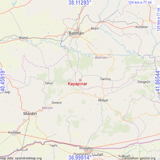
Kayapınar GPS coordinates[2]
37° 33' 27.432" North, 41° 9' 44.316" East
| Map corner | latitude | longitude |
|---|---|---|
| Upper-left | 38.11293°, | 40.45919° |
| Center: | 37.55762°, | 41.16231° |
| Lower-right: | 36.99814°, | 41.86544° |
| Map W x H: | 124×124 km | = 77.1×77.1mi |
| max Lat: | 42.02683° ⇑73.5% North |
| Kayapınar: | 37.55762° |
| min Lat: | ⇓26.5% South 35.9025° |
| min Long | Kayapınar | max Long |
| 25.90902° | 41.16231° | 44.60099° |
| W 82.6%⇐ | ⇒17.4% E |
Elevation
Elevation of Kayapınar is 1154 m = 3786 ft, and this is 436.6 m = 1432 ft above average elevation for this country.
| Max E: |
2682 m = 8799 ft | 22.1% |
| Kayapınar | 1154 m 3786 ft | |
| Avg. | 717.4 m = 2354 ft | |
Min E: |
0 m = 0 ft | 77.9% |
See also: Turkey elevation on elevation.city.
Geographical zone
Kayapınar is located in North temperate zone (between Tropic of Cancer and the Arctic Circle). Distance of this Northern Tropic circle is 1570.1 km =975.6 mi to South.| Distance of | km | miles | from Kayapınar |
|---|---|---|---|
| North Pole | 5831 | 3623.2 | to North |
| Arctic Circle | 3225.2 | 2004 | to North |
| Tropic Cancer | 1570.1 | 975.6 | to South |
| Equator | 4176 | 2594.8 | to South |


Nearby cities:
15 places around Kayapınar: (largest is in red/bold)
• Acırlı
16.3 km =10.1 mi,  134°
134°
• Düzoba
20.9 km =13 mi,  152°
152°
• Ebish
10.7 km =6.6 mi,  167°
167°
• Evkuran
20.8 km =12.9 mi,  303°
303°
• Gelinkaya
18.3 km =11.4 mi, 148°
• Gerdzhyush
19 km =11.8 mi,  88°
88°
• Hisar
7.5 km =4.7 mi,  50°
50°
• Kindirip
13.3 km =8.3 mi,  157°
157°
• Kozlu
20.2 km =12.6 mi,  64°
64°
• Reshidi
18.5 km =11.5 mi,  247°
247°
• Teffi
5.9 km =3.7 mi,  270°
270°
• Tokluca
11.5 km =7.1 mi,  284°
284°
• Yenilmez
16.1 km =10 mi, 250°
• Yolağzı
17.2 km =10.7 mi,  101°
101°
• Çavuşlu
9.8 km =6.1 mi, 129°
Sources, notices
• [Note1] Compared only with cities in Turkey existing in our database
• [Src1] Map data: © OpenStreetMap contributors (CC-BY-SA)
• [Src2] Other city data from geonames.org with taken over terms of usage.
• [Src3] Geographical zone / Annual Mean Temperature by Robert A. Rohde @ Wikipedia
