Reshidi geodata
Reshidi (Mardin) is a populated place; located in Turkey in Europe/Istanbul (GMT+3) time zone. With population of 1,220 people, there are 1050 cities with bigger population in this country. Compared to other cities in Turkey, 74.8% of cities are located further ↑North; 80.9% of cities are located further ←West and 76.6% of cities have lower elevation than Reshidi. Note1


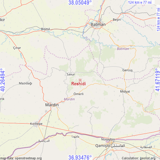
Reshidi GPS coordinates[2]
37° 29' 40.956" North, 40° 58' 5.016" East
| Map corner | latitude | longitude |
|---|---|---|
| Upper-left | 38.05049°, | 40.26494° |
| Center: | 37.49471°, | 40.96806° |
| Lower-right: | 36.93476°, | 41.67119° |
| Map W x H: | 124.1×124.1 km | = 77.1×77.1mi |
| max Lat: | 42.02683° ⇑74.8% North |
| Reshidi: | 37.49471° |
| min Lat: | ⇓25.2% South 35.9025° |
| min Long | Reshidi | max Long |
| 25.90902° | 40.96806° | 44.60099° |
| W 80.9%⇐ | ⇒19.1% E |
Elevation
Elevation of Reshidi is 1133 m = 3717 ft, and this is 415.6 m = 1364 ft above average elevation for this country.
| Max E: |
2682 m = 8799 ft | 23.4% |
| Reshidi | 1133 m 3717 ft | |
| Avg. | 717.4 m = 2354 ft | |
Min E: |
0 m = 0 ft | 76.6% |
See also: Turkey elevation on elevation.city.
Geographical zone
Reshidi is located in North temperate zone (between Tropic of Cancer and the Arctic Circle). Distance of this Northern Tropic circle is 1563.1 km =971.3 mi to South.| Distance of | km | miles | from Reshidi |
|---|---|---|---|
| North Pole | 5838 | 3627.6 | to North |
| Arctic Circle | 3232.2 | 2008.4 | to North |
| Tropic Cancer | 1563.1 | 971.3 | to South |
| Equator | 4169 | 2590.5 | to South |


Nearby cities:
15 places around Reshidi: (largest is in red/bold)
• Başkavak
10.5 km =6.5 mi,  317°
317°
• Dereyanı
12.1 km =7.5 mi,  231°
231°
• Ebish
19.8 km =12.3 mi,  100°
100°
• Evkuran
18.3 km =11.4 mi,  358°
358°
• Kayapınar
18.5 km =11.5 mi,  67°
67°
• Kayatepe
4.5 km =2.8 mi,  306°
306°
• Kaynakkaya
17.5 km =10.9 mi,  190°
190°
• Pınardere
12.1 km =7.5 mi,  258°
258°
• Savur
9.1 km =5.7 mi,  299°
299°
• Teffi
13.2 km =8.2 mi,  58°
58°
• Tokluca
11.7 km =7.3 mi,  31°
31°
• Yenilmez
2.5 km =1.6 mi,  50°
50°
• Yeşilalan
16.6 km =10.3 mi, 256°
• Çınaraltı
15.5 km =9.6 mi,  218°
218°
• Ömerli
10.7 km =6.6 mi, 186°
Sources, notices
• [Note1] Compared only with cities in Turkey existing in our database
• [Src1] Map data: © OpenStreetMap contributors (CC-BY-SA)
• [Src2] Other city data from geonames.org with taken over terms of usage.
• [Src3] Geographical zone / Annual Mean Temperature by Robert A. Rohde @ Wikipedia
