Hisar geodata
Hisar (Batman) is a populated place; located in Turkey in Europe/Istanbul (GMT+3) time zone. With population of 2,194 people, there are 922 cities with bigger population in this country. Compared to other cities in Turkey, 72% of cities are located further ↑North; 83.3% of cities are located further ←West and 60.4% of cities have lower elevation than Hisar. Note1


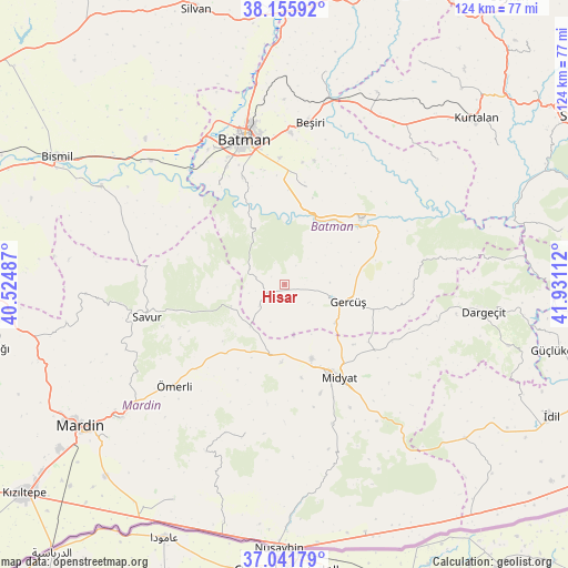
Hisar GPS coordinates[2]
37° 36' 3.384" North, 41° 13' 40.764" East
| Map corner | latitude | longitude |
|---|---|---|
| Upper-left | 38.15592°, | 40.52487° |
| Center: | 37.60094°, | 41.22799° |
| Lower-right: | 37.04179°, | 41.93112° |
| Map W x H: | 123.9×123.9 km | = 77×77mi |
| max Lat: | 42.02683° ⇑72% North |
| Hisar: | 37.60094° |
| min Lat: | ⇓28% South 35.9025° |
| min Long | Hisar | max Long |
| 25.90902° | 41.22799° | 44.60099° |
| W 83.3%⇐ | ⇒16.7% E |
Elevation
Elevation of Hisar is 889 m = 2917 ft, and this is 171.6 m = 563 ft above average elevation for this country.
| Max E: |
2682 m = 8799 ft | 39.6% |
| Hisar | 889 m 2917 ft | |
| Avg. | 717.4 m = 2354 ft | |
Min E: |
0 m = 0 ft | 60.4% |
See also: Turkey elevation on elevation.city.
Geographical zone
Hisar is located in North temperate zone (between Tropic of Cancer and the Arctic Circle). Distance of this Northern Tropic circle is 1574.9 km =978.6 mi to South.| Distance of | km | miles | from Hisar |
|---|---|---|---|
| North Pole | 5826.2 | 3620.2 | to North |
| Arctic Circle | 3220.3 | 2001 | to North |
| Tropic Cancer | 1574.9 | 978.6 | to South |
| Equator | 4180.8 | 2597.8 | to South |


Nearby cities:
15 places around Hisar: (largest is in red/bold)
• Acırlı
17.2 km =10.7 mi,  159°
159°
• Barıştepe
20.2 km =12.6 mi,  130°
130°
• Ebish
15.7 km =9.8 mi,  192°
192°
• Gelinkaya
20.8 km =12.9 mi,  169°
169°
• Gerdzhyush
13.9 km =8.6 mi,  107°
107°
• Hasankeyf
19.5 km =12.1 mi,  53°
53°
• Karaköy
18.6 km =11.6 mi,  60°
60°
• Kayapınar
7.5 km =4.7 mi,  230°
230°
• Kesmeköprü
20.8 km =12.9 mi, 51°
• Kindirip
17.1 km =10.6 mi,  182°
182°
• Kozlu
13 km =8.1 mi,  71°
71°
• Teffi
12.6 km =7.8 mi,  247°
247°
• Tokluca
17 km =10.6 mi,  263°
263°
• Yolağzı
13.9 km =8.6 mi, 127°
• Çavuşlu
11.2 km =7 mi, 170°
Sources, notices
• [Note1] Compared only with cities in Turkey existing in our database
• [Src1] Map data: © OpenStreetMap contributors (CC-BY-SA)
• [Src2] Other city data from geonames.org with taken over terms of usage.
• [Src3] Geographical zone / Annual Mean Temperature by Robert A. Rohde @ Wikipedia
