Karaköy geodata
Karaköy (Muş) is a seat of a third-order administrative division; located in Turkey in Europe/Istanbul (GMT+3) time zone. In our database, there are 1323 cities with bigger population. Compared to other cities in Turkey, 55.9% of cities are located further ↓South; 87.4% of cities are located further ←West and 97.9% of cities have lower elevation than Karaköy. Note1


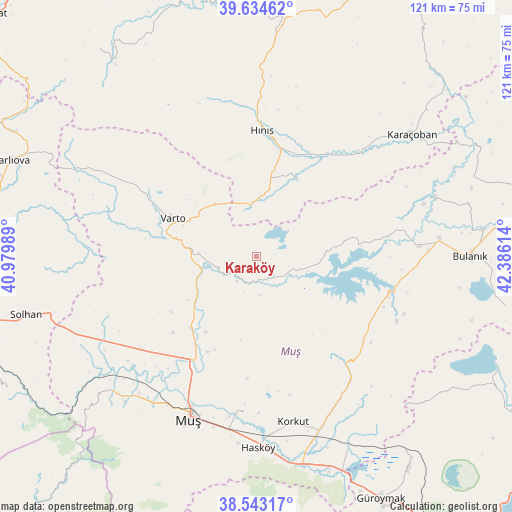
Karaköy GPS coordinates[2]
39° 5' 27.636" North, 41° 40' 58.836" East
| Map corner | latitude | longitude |
|---|---|---|
| Upper-left | 39.63462°, | 40.97989° |
| Center: | 39.09101°, | 41.68301° |
| Lower-right: | 38.54317°, | 42.38614° |
| Map W x H: | 121.4×121.4 km | = 75.4×75.4mi |
| max Lat: | 42.02683° ⇑44.1% North |
| Karaköy: | 39.09101° |
| min Lat: | ⇓55.9% South 35.9025° |
| min Long | Karaköy | max Long |
| 25.90902° | 41.68301° | 44.60099° |
| W 87.4%⇐ | ⇒12.6% E |
Elevation
Elevation of Karaköy is 1850 m = 6070 ft, and this is 1132.6 m = 3716 ft above average elevation for this country.
| Max E: |
2682 m = 8799 ft | 2.1% |
| Karaköy | 1850 m 6070 ft | |
| Avg. | 717.4 m = 2354 ft | |
Min E: |
0 m = 0 ft | 97.9% |
See also: Turkey elevation on elevation.city.
Geographical zone
Karaköy is located in North temperate zone (between Tropic of Cancer and the Arctic Circle). Distance of this Northern Tropic circle is 1740.6 km =1081.6 mi to South.| Distance of | km | miles | from Karaköy |
|---|---|---|---|
| North Pole | 5660.5 | 3517.3 | to North |
| Arctic Circle | 3054.7 | 1898.1 | to North |
| Tropic Cancer | 1740.6 | 1081.6 | to South |
| Equator | 4346.5 | 2700.8 | to South |


Nearby cities:
15 places around Karaköy: (largest is in red/bold)
• Bulanık
50.8 km =31.6 mi,  90°
90°
• Erentepe
32.5 km =20.2 mi,  106°
106°
• Halilçavuş
19.8 km =12.3 mi,  28°
28°
• Hasköy
45.4 km =28.2 mi,  180°
180°
• Hınıs
29.7 km =18.5 mi,  1°
1°
• Karaağıl
35 km =21.7 mi,  81°
81°
• Karaköprü
34.8 km =21.6 mi,  44°
44°
• Karaçoban
45.5 km =28.3 mi,  51°
51°
• Korkut
40.7 km =25.3 mi,  167°
167°
• Kızılağaç
47.1 km =29.3 mi,  222°
222°
• Mercimekkale
23.7 km =14.7 mi, 220°
• Muş
43.5 km =27 mi,  203°
203°
• Varto
21.8 km =13.5 mi,  294°
294°
• Yaygın
39 km =24.2 mi,  236°
236°
• Çaylar
39.6 km =24.6 mi,  299°
299°
Sources, notices
• [Note1] Compared only with cities in Turkey existing in our database
• [Src1] Map data: © OpenStreetMap contributors (CC-BY-SA)
• [Src2] Other city data from geonames.org with taken over terms of usage.
• [Src3] Geographical zone / Annual Mean Temperature by Robert A. Rohde @ Wikipedia
