Hınıs geodata
Hınıs (Erzurum) is a seat of a second-order administrative division; located in Turkey in Europe/Istanbul (GMT+3) time zone. With population of 35,472 people, there are 221 cities with bigger population in this country. Compared to other cities in Turkey, 59.6% of cities are located further ↓South; 87.6% of cities are located further ←West and 95.6% of cities have lower elevation than Hınıs. Note1


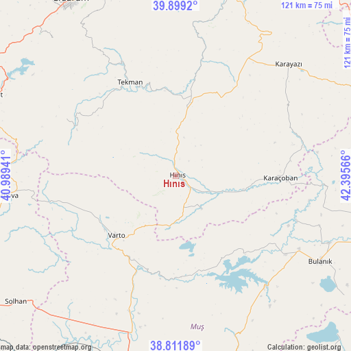
Hınıs GPS coordinates[2]
39° 21' 27.576" North, 41° 41' 33.108" East
| Map corner | latitude | longitude |
|---|---|---|
| Upper-left | 39.8992°, | 40.98941° |
| Center: | 39.35766°, | 41.69253° |
| Lower-right: | 38.81189°, | 42.39566° |
| Map W x H: | 120.9×120.9 km | = 75.1×75.1mi |
| max Lat: | 42.02683° ⇑40.4% North |
| Hınıs: | 39.35766° |
| min Lat: | ⇓59.6% South 35.9025° |
| min Long | Hınıs | max Long |
| 25.90902° | 41.69253° | 44.60099° |
| W 87.6%⇐ | ⇒12.4% E |
Elevation
Elevation of Hınıs is 1700 m = 5577 ft, and this is 982.6 m = 3224 ft above average elevation for this country.
| Max E: |
2682 m = 8799 ft | 4.4% |
| Hınıs | 1700 m 5577 ft | |
| Avg. | 717.4 m = 2354 ft | |
Min E: |
0 m = 0 ft | 95.6% |
See also: Turkey elevation on elevation.city.
Geographical zone
Hınıs is located in North temperate zone (between Tropic of Cancer and the Arctic Circle). Distance of this Northern Tropic circle is 1770.2 km =1100 mi to South.| Distance of | km | miles | from Hınıs |
|---|---|---|---|
| North Pole | 5630.9 | 3498.9 | to North |
| Arctic Circle | 3025 | 1879.6 | to North |
| Tropic Cancer | 1770.2 | 1100 | to South |
| Equator | 4376.2 | 2719.2 | to South |


Nearby cities:
15 places around Hınıs: (largest is in red/bold)
• Aktuzla
51.1 km =31.8 mi,  93°
93°
• Erentepe
49.2 km =30.6 mi,  142°
142°
• Gökoğlan
39.4 km =24.5 mi,  302°
302°
• Göksu
42 km =26.1 mi,  69°
69°
• Halilçavuş
15 km =9.3 mi, 144°
• Karaağıl
41.8 km =26 mi,  126°
126°
• Karaköprü
23.9 km =14.9 mi,  101°
101°
• Karaköy
29.7 km =18.5 mi,  181°
181°
• Karayazı
53.9 km =33.5 mi,  45°
45°
• Karaçoban
35 km =21.7 mi, 92°
• Mercimekkale
50.3 km =31.3 mi,  198°
198°
• Söylemez
45.8 km =28.5 mi,  11°
11°
• Tekman
35.4 km =22 mi,  333°
333°
• Varto
29 km =18 mi,  225°
225°
• Çaylar
36.6 km =22.7 mi,  254°
254°
Sources, notices
• [Note1] Compared only with cities in Turkey existing in our database
• [Src1] Map data: © OpenStreetMap contributors (CC-BY-SA)
• [Src2] Other city data from geonames.org with taken over terms of usage.
• [Src3] Geographical zone / Annual Mean Temperature by Robert A. Rohde @ Wikipedia
