Varto geodata
Varto (Muş) is a seat of a second-order administrative division; located in Turkey in Europe/Istanbul (GMT+3) time zone. With population of 18,691 people, there are 348 cities with bigger population in this country. Compared to other cities in Turkey, 57% of cities are located further ↓South; 85.8% of cities are located further ←West and 91.4% of cities have lower elevation than Varto. Note1


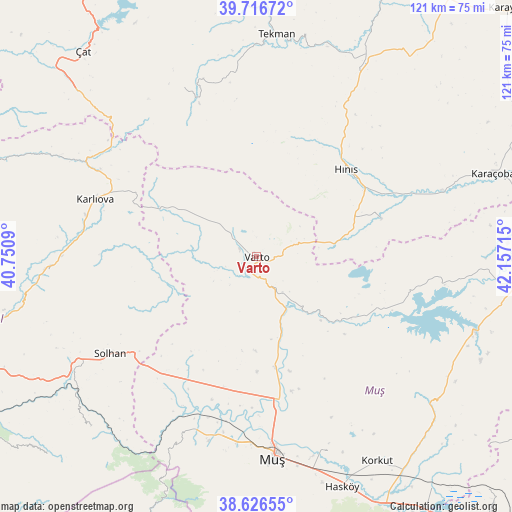
Varto GPS coordinates[2]
39° 10' 25.5" North, 41° 27' 14.472" East
| Map corner | latitude | longitude |
|---|---|---|
| Upper-left | 39.71672°, | 40.7509° |
| Center: | 39.17375°, | 41.45402° |
| Lower-right: | 38.62655°, | 42.15715° |
| Map W x H: | 121.2×121.2 km | = 75.3×75.3mi |
| max Lat: | 42.02683° ⇑43% North |
| Varto: | 39.17375° |
| min Lat: | ⇓57% South 35.9025° |
| min Long | Varto | max Long |
| 25.90902° | 41.45402° | 44.60099° |
| W 85.8%⇐ | ⇒14.2% E |
Elevation
Elevation of Varto is 1523 m = 4997 ft, and this is 805.6 m = 2643 ft above average elevation for this country.
| Max E: |
2682 m = 8799 ft | 8.6% |
| Varto | 1523 m 4997 ft | |
| Avg. | 717.4 m = 2354 ft | |
Min E: |
0 m = 0 ft | 91.4% |
See also: Turkey elevation on elevation.city.
Geographical zone
Varto is located in North temperate zone (between Tropic of Cancer and the Arctic Circle). Distance of this Northern Tropic circle is 1749.8 km =1087.3 mi to South.| Distance of | km | miles | from Varto |
|---|---|---|---|
| North Pole | 5651.3 | 3511.6 | to North |
| Arctic Circle | 3045.5 | 1892.4 | to North |
| Tropic Cancer | 1749.8 | 1087.3 | to South |
| Equator | 4355.7 | 2706.5 | to South |


Nearby cities:
15 places around Varto: (largest is in red/bold)
• Erentepe
54.1 km =33.6 mi,  109°
109°
• Gökoğlan
43.4 km =27 mi,  342°
342°
• Göynük
50.1 km =31.1 mi,  265°
265°
• Halilçavuş
30.3 km =18.8 mi,  74°
74°
• Hınıs
29 km =18 mi,  45°
45°
• Karaköprü
46.7 km =29 mi, 70°
• Karaköy
21.8 km =13.5 mi, 114°
• Karlıova
40.7 km =25.3 mi,  288°
288°
• Kızılağaç
45.4 km =28.2 mi,  195°
195°
• Mercimekkale
27.5 km =17.1 mi,  171°
171°
• Muş
49.2 km =30.6 mi,  176°
176°
• Solhan
41.6 km =25.8 mi,  236°
236°
• Tekman
52.2 km =32.4 mi,  4°
4°
• Yaygın
33.3 km =20.7 mi, 202°
• Çaylar
18 km =11.2 mi,  305°
305°
Sources, notices
• [Note1] Compared only with cities in Turkey existing in our database
• [Src1] Map data: © OpenStreetMap contributors (CC-BY-SA)
• [Src2] Other city data from geonames.org with taken over terms of usage.
• [Src3] Geographical zone / Annual Mean Temperature by Robert A. Rohde @ Wikipedia
