Korkut geodata
Korkut (Muş) is a seat of a second-order administrative division; located in Turkey in Europe/Istanbul (GMT+3) time zone. With population of 8,078 people, there are 574 cities with bigger population in this country. Compared to other cities in Turkey, 50.6% of cities are located further ↓South; 88.3% of cities are located further ←West and 84.5% of cities have lower elevation than Korkut. Note1


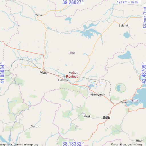
Korkut GPS coordinates[2]
38° 44' 2.04" North, 41° 47' 2.256" East
| Map corner | latitude | longitude |
|---|---|---|
| Upper-left | 39.28027°, | 41.08084° |
| Center: | 38.7339°, | 41.78396° |
| Lower-right: | 38.18332°, | 42.48709° |
| Map W x H: | 122×122 km | = 75.8×75.8mi |
| max Lat: | 42.02683° ⇑49.4% North |
| Korkut: | 38.7339° |
| min Lat: | ⇓50.6% South 35.9025° |
| min Long | Korkut | max Long |
| 25.90902° | 41.78396° | 44.60099° |
| W 88.3%⇐ | ⇒11.7% E |
Elevation
Elevation of Korkut is 1295 m = 4249 ft, and this is 577.6 m = 1895 ft above average elevation for this country.
| Max E: |
2682 m = 8799 ft | 15.5% |
| Korkut | 1295 m 4249 ft | |
| Avg. | 717.4 m = 2354 ft | |
Min E: |
0 m = 0 ft | 84.5% |
See also: Turkey elevation on elevation.city.
Geographical zone
Korkut is located in North temperate zone (between Tropic of Cancer and the Arctic Circle). Distance of this Northern Tropic circle is 1700.9 km =1056.9 mi to South.| Distance of | km | miles | from Korkut |
|---|---|---|---|
| North Pole | 5700.3 | 3542 | to North |
| Arctic Circle | 3094.4 | 1922.8 | to North |
| Tropic Cancer | 1700.9 | 1056.9 | to South |
| Equator | 4306.8 | 2676.1 | to South |


Nearby cities:
15 places around Korkut: (largest is in red/bold)
• Bitlis
46.5 km =28.9 mi,  142°
142°
• Erentepe
38 km =23.6 mi,  36°
36°
• Geyikpınar
46.4 km =28.8 mi,  176°
176°
• Güroymak
26.7 km =16.6 mi,  131°
131°
• Hasköy
10.8 km =6.7 mi,  237°
237°
• Karaköy
40.7 km =25.3 mi,  347°
347°
• Kavakbaşı
28 km =17.4 mi,  173°
173°
• Kızılağaç
41.1 km =25.5 mi,  277°
277°
• Mercimekkale
32.6 km =20.3 mi,  311°
311°
• Meydan
42.1 km =26.2 mi, 181°
• Mutki
38.3 km =23.8 mi,  161°
161°
• Muş
25.9 km =16.1 mi,  269°
269°
• Ovakışla
47.1 km =29.3 mi,  78°
78°
• Tatvan
51 km =31.7 mi,  121°
121°
• Yaygın
45.2 km =28.1 mi,  293°
293°
Sources, notices
• [Note1] Compared only with cities in Turkey existing in our database
• [Src1] Map data: © OpenStreetMap contributors (CC-BY-SA)
• [Src2] Other city data from geonames.org with taken over terms of usage.
• [Src3] Geographical zone / Annual Mean Temperature by Robert A. Rohde @ Wikipedia
