Karaağıl geodata
Karaağıl (Muş) is a seat of a third-order administrative division; located in Turkey in Europe/Istanbul (GMT+3) time zone. In our database, there are 1323 cities with bigger population. Compared to other cities in Turkey, 56.5% of cities are located further ↓South; 90.9% of cities are located further ←West and 89.6% of cities have lower elevation than Karaağıl. Note1


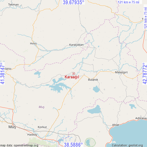
Karaağıl GPS coordinates[2]
39° 8' 9.924" North, 42° 5' 4.524" East
| Map corner | latitude | longitude |
|---|---|---|
| Upper-left | 39.67935°, | 41.38147° |
| Center: | 39.13609°, | 42.08459° |
| Lower-right: | 38.5886°, | 42.78772° |
| Map W x H: | 121.3×121.3 km | = 75.4×75.4mi |
| max Lat: | 42.02683° ⇑43.5% North |
| Karaağıl: | 39.13609° |
| min Lat: | ⇓56.5% South 35.9025° |
| min Long | Karaağıl | max Long |
| 25.90902° | 42.08459° | 44.60099° |
| W 90.9%⇐ | ⇒9.1% E |
Elevation
Elevation of Karaağıl is 1461 m = 4793 ft, and this is 743.6 m = 2440 ft above average elevation for this country.
| Max E: |
2682 m = 8799 ft | 10.4% |
| Karaağıl | 1461 m 4793 ft | |
| Avg. | 717.4 m = 2354 ft | |
Min E: |
0 m = 0 ft | 89.6% |
See also: Turkey elevation on elevation.city.
Geographical zone
Karaağıl is located in North temperate zone (between Tropic of Cancer and the Arctic Circle). Distance of this Northern Tropic circle is 1745.6 km =1084.7 mi to South.| Distance of | km | miles | from Karaağıl |
|---|---|---|---|
| North Pole | 5655.5 | 3514.2 | to North |
| Arctic Circle | 3049.6 | 1894.9 | to North |
| Tropic Cancer | 1745.6 | 1084.7 | to South |
| Equator | 4351.5 | 2703.9 | to South |


Nearby cities:
15 places around Karaağıl: (largest is in red/bold)
• Aktuzla
27.6 km =17.1 mi,  38°
38°
• Bulanık
17 km =10.6 mi,  108°
108°
• Erentepe
14.6 km =9.1 mi,  194°
194°
• Göksu
39.7 km =24.7 mi,  8°
8°
• Halilçavuş
28 km =17.4 mi,  296°
296°
• Hınıs
41.8 km =26 mi,  306°
306°
• Karaköprü
22.4 km =13.9 mi,  332°
332°
• Karaköy
35 km =21.7 mi,  261°
261°
• Karaçoban
23.1 km =14.4 mi,  3°
3°
• Korkut
51.7 km =32.1 mi,  210°
210°
• Malazgirt
38.9 km =24.2 mi,  88°
88°
• Nurettin
30.6 km =19 mi,  70°
70°
• Nurettin
39.8 km =24.7 mi, 66°
• Ovakışla
40.7 km =25.3 mi,  150°
150°
• Varto
54.5 km =33.9 mi,  274°
274°
Sources, notices
• [Note1] Compared only with cities in Turkey existing in our database
• [Src1] Map data: © OpenStreetMap contributors (CC-BY-SA)
• [Src2] Other city data from geonames.org with taken over terms of usage.
• [Src3] Geographical zone / Annual Mean Temperature by Robert A. Rohde @ Wikipedia
