Sarıbeyler geodata
Sarıbeyler (Balıkesir) is a seat of a third-order administrative division; located in Turkey in Europe/Istanbul (GMT+3) time zone. In our database, there are 1323 cities with bigger population. Compared to other cities in Turkey, 60% of cities are located further ↓South; 93.1% of cities are located further →East and 71.1% of cities have higher elevation than Sarıbeyler. Note1


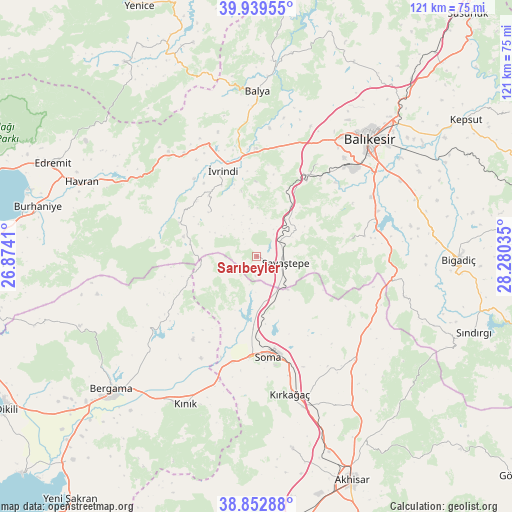
Sarıbeyler GPS coordinates[2]
39° 23' 53.988" North, 27° 34' 37.992" East
| Map corner | latitude | longitude |
|---|---|---|
| Upper-left | 39.93955°, | 26.8741° |
| Center: | 39.39833°, | 27.57722° |
| Lower-right: | 38.85288°, | 28.28035° |
| Map W x H: | 120.8×120.8 km | = 75.1×75.1mi |
| max Lat: | 42.02683° ⇑40% North |
| Sarıbeyler: | 39.39833° |
| min Lat: | ⇓60% South 35.9025° |
| min Long | Sarıbeyler | max Long |
| 25.90902° | 27.57722° | 44.60099° |
| W 6.9%⇐ | ⇒93.1% E |
Elevation
Elevation of Sarıbeyler is 260 m = 853 ft, and this is 457.4 m = 1501 ft below average elevation for this country.
| Max E: |
2682 m = 8799 ft | 71.1% |
| Avg. | 717.4 m = 2354 ft | |
| Sarıbeyler | 260 m = 853 ft | |
Min E: |
0 m = 0 ft | 28.9% |
See also: Turkey elevation on elevation.city.
Geographical zone
Sarıbeyler is located in North temperate zone (between Tropic of Cancer and the Arctic Circle). Distance of this Northern Tropic circle is 1774.8 km =1102.8 mi to South.| Distance of | km | miles | from Sarıbeyler |
|---|---|---|---|
| North Pole | 5626.4 | 3496.1 | to North |
| Arctic Circle | 3020.5 | 1876.9 | to North |
| Tropic Cancer | 1774.8 | 1102.8 | to South |
| Equator | 4380.7 | 2722 | to South |


Nearby cities:
15 places around Sarıbeyler: (largest is in red/bold)
• Balıkesir
38.5 km =23.9 mi,  43°
43°
• Ergama
25.9 km =16.1 mi,  10°
10°
• Ertuğrul
22.6 km =14 mi,  29°
29°
• Gelembe
33.8 km =21 mi,  136°
136°
• Gölcük
36.2 km =22.5 mi,  105°
105°
• Göçbeyli
24.5 km =15.2 mi,  217°
217°
• Kayapa
15.4 km =9.6 mi,  312°
312°
• Konakpınar
22.6 km =14 mi,  79°
79°
• Korucu
19.9 km =12.4 mi,  293°
293°
• Kınık
38.4 km =23.9 mi,  205°
205°
• Kırkağaç
33.4 km =20.8 mi,  166°
166°
• Savaştepe
7 km =4.3 mi,  103°
103°
• Soma
23.8 km =14.8 mi, 173°
• Turanlı
25.6 km =15.9 mi,  238°
238°
• İvrindi
22.1 km =13.7 mi,  339°
339°
Sources, notices
• [Note1] Compared only with cities in Turkey existing in our database
• [Src1] Map data: © OpenStreetMap contributors (CC-BY-SA)
• [Src2] Other city data from geonames.org with taken over terms of usage.
• [Src3] Geographical zone / Annual Mean Temperature by Robert A. Rohde @ Wikipedia
