Gyundyukoru geodata
Gyundyukoru (Mardin) is a populated place; located in Turkey in Europe/Istanbul (GMT+3) time zone. With population of 1,507 people, there are 1007 cities with bigger population in this country. Compared to other cities in Turkey, 85.4% of cities are located further ↑North; 76.4% of cities are located further ←West and 62.7% of cities have higher elevation than Gyundyukoru. Note1


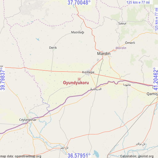
Gyundyukoru GPS coordinates[2]
37° 8' 31.452" North, 40° 30' 5.364" East
| Map corner | latitude | longitude |
|---|---|---|
| Upper-left | 37.70048°, | 39.79837° |
| Center: | 37.14207°, | 40.50149° |
| Lower-right: | 36.57951°, | 41.20462° |
| Map W x H: | 124.6×124.6 km | = 77.4×77.4mi |
| max Lat: | 42.02683° ⇑85.4% North |
| Gyundyukoru: | 37.14207° |
| min Lat: | ⇓14.6% South 35.9025° |
| min Long | Gyundyukoru | max Long |
| 25.90902° | 40.50149° | 44.60099° |
| W 76.4%⇐ | ⇒23.6% E |
Elevation
Elevation of Gyundyukoru is 459 m = 1506 ft, and this is 258.4 m = 848 ft below average elevation for this country.
| Max E: |
2682 m = 8799 ft | 62.7% |
| Avg. | 717.4 m = 2354 ft | |
| Gyundyukoru | 459 m = 1506 ft | |
Min E: |
0 m = 0 ft | 37.3% |
See also: Turkey elevation on elevation.city.
Geographical zone
Gyundyukoru is located in North temperate zone (between Tropic of Cancer and the Arctic Circle). Distance of this Northern Tropic circle is 1523.9 km =946.9 mi to South.| Distance of | km | miles | from Gyundyukoru |
|---|---|---|---|
| North Pole | 5877.3 | 3652 | to North |
| Arctic Circle | 3271.4 | 2032.8 | to North |
| Tropic Cancer | 1523.9 | 946.9 | to South |
| Equator | 4129.8 | 2566.1 | to South |


Nearby cities:
15 places around Gyundyukoru: (largest is in red/bold)
• Akyazı
6.1 km =3.8 mi,  68°
68°
• Akziyaret
6.2 km =3.9 mi,  357°
357°
• Doyuran
12.3 km =7.6 mi,  100°
100°
• Elbeyli
13.4 km =8.3 mi, 69°
• Eskin
17.7 km =11 mi,  62°
62°
• Eymirli
16.7 km =10.4 mi,  79°
79°
• Eşme
12.5 km =7.8 mi, 83°
• Karakuyu
4.2 km =2.6 mi, 62°
• Kocalar
18.5 km =11.5 mi,  42°
42°
• Kyanisipi
5.5 km =3.4 mi,  107°
107°
• Kızıltepe
8.5 km =5.3 mi,  52°
52°
• Sancarlı
17.7 km =11 mi, 41°
• Selah
18.7 km =11.6 mi, 67°
• Yaşarköy
7.4 km =4.6 mi,  150°
150°
• Şenyurt
14.3 km =8.9 mi,  119°
119°
Sources, notices
• [Note1] Compared only with cities in Turkey existing in our database
• [Src1] Map data: © OpenStreetMap contributors (CC-BY-SA)
• [Src2] Other city data from geonames.org with taken over terms of usage.
• [Src3] Geographical zone / Annual Mean Temperature by Robert A. Rohde @ Wikipedia
