Kyanisipi geodata
Kyanisipi (Mardin) is a populated place; located in Turkey in Europe/Istanbul (GMT+3) time zone. With population of 852 people, there are 1134 cities with bigger population in this country. Compared to other cities in Turkey, 85.8% of cities are located further ↑North; 76.9% of cities are located further ←West and 62.4% of cities have higher elevation than Kyanisipi. Note1


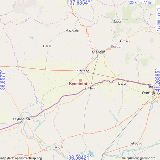
Kyanisipi GPS coordinates[2]
37° 7' 36.768" North, 40° 33' 38.952" East
| Map corner | latitude | longitude |
|---|---|---|
| Upper-left | 37.6854°, | 39.8577° |
| Center: | 37.12688°, | 40.56082° |
| Lower-right: | 36.56421°, | 41.26395° |
| Map W x H: | 124.7×124.7 km | = 77.5×77.5mi |
| max Lat: | 42.02683° ⇑85.8% North |
| Kyanisipi: | 37.12688° |
| min Lat: | ⇓14.2% South 35.9025° |
| min Long | Kyanisipi | max Long |
| 25.90902° | 40.56082° | 44.60099° |
| W 76.9%⇐ | ⇒23.1% E |
Elevation
Elevation of Kyanisipi is 465 m = 1526 ft, and this is 252.4 m = 828 ft below average elevation for this country.
| Max E: |
2682 m = 8799 ft | 62.4% |
| Avg. | 717.4 m = 2354 ft | |
| Kyanisipi | 465 m = 1526 ft | |
Min E: |
0 m = 0 ft | 37.6% |
See also: Turkey elevation on elevation.city.
Geographical zone
Kyanisipi is located in North temperate zone (between Tropic of Cancer and the Arctic Circle). Distance of this Northern Tropic circle is 1522.2 km =945.9 mi to South.| Distance of | km | miles | from Kyanisipi |
|---|---|---|---|
| North Pole | 5878.9 | 3653 | to North |
| Arctic Circle | 3273.1 | 2033.8 | to North |
| Tropic Cancer | 1522.2 | 945.9 | to South |
| Equator | 4128.1 | 2565.1 | to South |


Nearby cities:
15 places around Kyanisipi: (largest is in red/bold)
• Akyazı
3.9 km =2.4 mi,  6°
6°
• Akziyaret
9.6 km =6 mi,  324°
324°
• Boztepe
15.4 km =9.6 mi,  65°
65°
• Doyuran
6.8 km =4.2 mi,  93°
93°
• Elbeyli
9.7 km =6 mi,  49°
49°
• Eskin
14.3 km =8.9 mi, 46°
• Eymirli
12.2 km =7.6 mi, 66°
• Eşme
7.8 km =4.8 mi, 65°
• Gyundyukoru
5.5 km =3.4 mi,  287°
287°
• Karakuyu
3.9 km =2.4 mi,  337°
337°
• Kızıltepe
7 km =4.3 mi, 12°
• Sancarlı
16.3 km =10.1 mi,  23°
23°
• Selah
14.9 km =9.3 mi, 54°
• Yaşarköy
5 km =3.1 mi,  199°
199°
• Şenyurt
9 km =5.6 mi,  126°
126°
Sources, notices
• [Note1] Compared only with cities in Turkey existing in our database
• [Src1] Map data: © OpenStreetMap contributors (CC-BY-SA)
• [Src2] Other city data from geonames.org with taken over terms of usage.
• [Src3] Geographical zone / Annual Mean Temperature by Robert A. Rohde @ Wikipedia
