Yaşarköy geodata
Yaşarköy (Mardin) is a populated place; located in Turkey in Europe/Istanbul (GMT+3) time zone. With population of 547 people, there are 1281 cities with bigger population in this country. Compared to other cities in Turkey, 86.5% of cities are located further ↑North; 76.6% of cities are located further ←West and 62.7% of cities have higher elevation than Yaşarköy. Note1


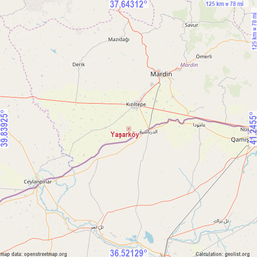
Yaşarköy GPS coordinates[2]
37° 5' 3.408" North, 40° 32' 32.532" East
| Map corner | latitude | longitude |
|---|---|---|
| Upper-left | 37.64312°, | 39.83925° |
| Center: | 37.08428°, | 40.54237° |
| Lower-right: | 36.52129°, | 41.2455° |
| Map W x H: | 124.7×124.7 km | = 77.5×77.5mi |
| max Lat: | 42.02683° ⇑86.5% North |
| Yaşarköy: | 37.08428° |
| min Lat: | ⇓13.5% South 35.9025° |
| min Long | Yaşarköy | max Long |
| 25.90902° | 40.54237° | 44.60099° |
| W 76.6%⇐ | ⇒23.4% E |
Elevation
Elevation of Yaşarköy is 459 m = 1506 ft, and this is 258.4 m = 848 ft below average elevation for this country.
| Max E: |
2682 m = 8799 ft | 62.7% |
| Avg. | 717.4 m = 2354 ft | |
| Yaşarköy | 459 m = 1506 ft | |
Min E: |
0 m = 0 ft | 37.3% |
See also: Turkey elevation on elevation.city.
Geographical zone
Yaşarköy is located in North temperate zone (between Tropic of Cancer and the Arctic Circle). Distance of this Northern Tropic circle is 1517.5 km =942.9 mi to South.| Distance of | km | miles | from Yaşarköy |
|---|---|---|---|
| North Pole | 5883.7 | 3656 | to North |
| Arctic Circle | 3277.8 | 2036.7 | to North |
| Tropic Cancer | 1517.5 | 942.9 | to South |
| Equator | 4123.4 | 2562.2 | to South |


Nearby cities:
15 places around Yaşarköy: (largest is in red/bold)
• Akyazı
8.9 km =5.5 mi,  13°
13°
• Akziyaret
13.2 km =8.2 mi,  342°
342°
• Boztepe
19.1 km =11.9 mi,  54°
54°
• Doyuran
9.5 km =5.9 mi,  63°
63°
• Elbeyli
14.3 km =8.9 mi,  39°
39°
• Eskin
18.9 km =11.7 mi, 39°
• Eymirli
16 km =9.9 mi, 53°
• Eşme
11.8 km =7.3 mi, 47°
• Gyundyukoru
7.4 km =4.6 mi,  330°
330°
• Karakuyu
8.3 km =5.2 mi,  0°
0°
• Kumlu
19.7 km =12.2 mi, 60°
• Kyanisipi
5 km =3.1 mi,  19°
19°
• Kızıltepe
12 km =7.5 mi, 14°
• Selah
19.2 km =11.9 mi, 45°
• Şenyurt
8.9 km =5.5 mi,  93°
93°
Sources, notices
• [Note1] Compared only with cities in Turkey existing in our database
• [Src1] Map data: © OpenStreetMap contributors (CC-BY-SA)
• [Src2] Other city data from geonames.org with taken over terms of usage.
• [Src3] Geographical zone / Annual Mean Temperature by Robert A. Rohde @ Wikipedia
