Ergani geodata
Ergani (Diyarbakır) is a seat of a second-order administrative division; located in Turkey in Europe/Istanbul (GMT+3) time zone. With population of 52,684 people, there are 164 cities with bigger population in this country. Compared to other cities in Turkey, 56.7% of cities are located further ↑North; 72.3% of cities are located further ←West and 63.8% of cities have lower elevation than Ergani. Note1


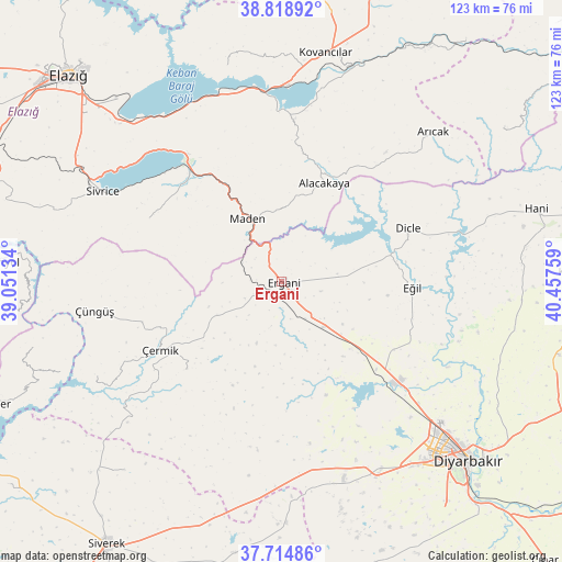
Ergani GPS coordinates[2]
38° 16' 8.364" North, 39° 45' 16.056" East
| Map corner | latitude | longitude |
|---|---|---|
| Upper-left | 38.81892°, | 39.05134° |
| Center: | 38.26899°, | 39.75446° |
| Lower-right: | 37.71486°, | 40.45759° |
| Map W x H: | 122.8×122.8 km | = 76.3×76.3mi |
| max Lat: | 42.02683° ⇑56.7% North |
| Ergani: | 38.26899° |
| min Lat: | ⇓43.3% South 35.9025° |
| min Long | Ergani | max Long |
| 25.90902° | 39.75446° | 44.60099° |
| W 72.3%⇐ | ⇒27.7% E |
Elevation
Elevation of Ergani is 944 m = 3097 ft, and this is 226.6 m = 743 ft above average elevation for this country.
| Max E: |
2682 m = 8799 ft | 36.2% |
| Ergani | 944 m 3097 ft | |
| Avg. | 717.4 m = 2354 ft | |
Min E: |
0 m = 0 ft | 63.8% |
See also: Ergani elevation on elevation.city.
Geographical zone
Ergani is located in North temperate zone (between Tropic of Cancer and the Arctic Circle). Distance of this Northern Tropic circle is 1649.2 km =1024.8 mi to South.| Distance of | km | miles | from Ergani |
|---|---|---|---|
| North Pole | 5751.9 | 3574.1 | to North |
| Arctic Circle | 3146.1 | 1954.9 | to North |
| Tropic Cancer | 1649.2 | 1024.8 | to South |
| Equator | 4255.1 | 2644 | to South |


Nearby cities:
15 places around Ergani: (largest is in red/bold)
• Ahmetli
13.5 km =8.4 mi,  138°
138°
• Alacakaya
22.9 km =14.2 mi,  23°
23°
• Arıcak
46 km =28.6 mi,  44°
44°
• Dicle
29.1 km =18.1 mi,  68°
68°
• Eğil
28 km =17.4 mi,  92°
92°
• Hazar
31.7 km =19.7 mi,  294°
294°
• Maden
15.3 km =9.5 mi,  328°
328°
• Palu
49.1 km =30.5 mi, 17°
• Sivrice
43.3 km =26.9 mi,  296°
296°
• Yolboyu
46.6 km =29 mi,  152°
152°
• Yoğun
28.3 km =17.6 mi,  228°
228°
• Çaybağı
48.7 km =30.3 mi,  346°
346°
• Çermik
30.9 km =19.2 mi,  241°
241°
• Çüngüş
41.5 km =25.8 mi,  260°
260°
• İçme
42.1 km =26.2 mi,  335°
335°
Sources, notices
• [Note1] Compared only with cities in Turkey existing in our database
• [Src1] Map data: © OpenStreetMap contributors (CC-BY-SA)
• [Src2] Other city data from geonames.org with taken over terms of usage.
• [Src3] Geographical zone / Annual Mean Temperature by Robert A. Rohde @ Wikipedia
