Hani geodata
Hani (Diyarbakır) is a seat of a second-order administrative division; located in Turkey in Europe/Istanbul (GMT+3) time zone. With population of 11,055 people, there are 481 cities with bigger population in this country. Compared to other cities in Turkey, 54.3% of cities are located further ↑North; 75.7% of cities are located further ←West and 60.2% of cities have lower elevation than Hani. Note1


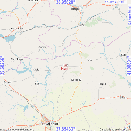
Hani GPS coordinates[2]
38° 24' 26.676" North, 40° 23' 8.808" East
| Map corner | latitude | longitude |
|---|---|---|
| Upper-left | 38.95628°, | 39.68266° |
| Center: | 38.40741°, | 40.38578° |
| Lower-right: | 37.85433°, | 41.08891° |
| Map W x H: | 122.5×122.5 km | = 76.1×76.1mi |
| max Lat: | 42.02683° ⇑54.3% North |
| Hani: | 38.40741° |
| min Lat: | ⇓45.7% South 35.9025° |
| min Long | Hani | max Long |
| 25.90902° | 40.38578° | 44.60099° |
| W 75.7%⇐ | ⇒24.3% E |
Elevation
Elevation of Hani is 886 m = 2907 ft, and this is 168.6 m = 553 ft above average elevation for this country.
| Max E: |
2682 m = 8799 ft | 39.8% |
| Hani | 886 m 2907 ft | |
| Avg. | 717.4 m = 2354 ft | |
Min E: |
0 m = 0 ft | 60.2% |
See also: Turkey elevation on elevation.city.
Geographical zone
Hani is located in North temperate zone (between Tropic of Cancer and the Arctic Circle). Distance of this Northern Tropic circle is 1664.6 km =1034.3 mi to South.| Distance of | km | miles | from Hani |
|---|---|---|---|
| North Pole | 5736.6 | 3564.6 | to North |
| Arctic Circle | 3130.7 | 1945.3 | to North |
| Tropic Cancer | 1664.6 | 1034.3 | to South |
| Equator | 4270.5 | 2653.6 | to South |


Nearby cities:
15 places around Hani: (largest is in red/bold)
• Alacakaya
46.2 km =28.7 mi,  276°
276°
• Arıcak
28.6 km =17.8 mi,  307°
307°
• Bağdere
44.5 km =27.7 mi,  136°
136°
• Dicle
28.4 km =17.6 mi,  260°
260°
• Eğil
31.9 km =19.8 mi,  238°
238°
• Genç
40.5 km =25.2 mi,  21°
21°
• Gökdere
40.4 km =25.1 mi,  337°
337°
• Hazro
38 km =23.6 mi,  117°
117°
• Kayacık
21.2 km =13.2 mi,  110°
110°
• Kocaköy
16.4 km =10.2 mi, 143°
• Lice
22.8 km =14.2 mi,  75°
75°
• Mermer
32.6 km =20.3 mi,  170°
170°
• Servi
19 km =11.8 mi, 342°
• Yamaç
41.3 km =25.7 mi,  6°
6°
• Yayla
27.8 km =17.3 mi,  26°
26°
Sources, notices
• [Note1] Compared only with cities in Turkey existing in our database
• [Src1] Map data: © OpenStreetMap contributors (CC-BY-SA)
• [Src2] Other city data from geonames.org with taken over terms of usage.
• [Src3] Geographical zone / Annual Mean Temperature by Robert A. Rohde @ Wikipedia
