Derebucak geodata
Derebucak (Konya) is a seat of a second-order administrative division; located in Turkey in Europe/Istanbul (GMT+3) time zone. With population of 5,035 people, there are 723 cities with bigger population in this country. Compared to other cities in Turkey, 77.6% of cities are located further ↑North; 68.8% of cities are located further →East and 81.7% of cities have lower elevation than Derebucak. Note1


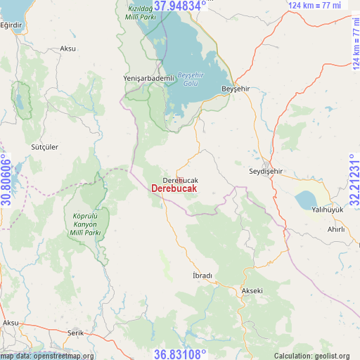
Derebucak GPS coordinates[2]
37° 23' 30.444" North, 31° 30' 33.048" East
| Map corner | latitude | longitude |
|---|---|---|
| Upper-left | 37.94834°, | 30.80606° |
| Center: | 37.39179°, | 31.50918° |
| Lower-right: | 36.83108°, | 32.21231° |
| Map W x H: | 124.2×124.2 km | = 77.2×77.2mi |
| max Lat: | 42.02683° ⇑77.6% North |
| Derebucak: | 37.39179° |
| min Lat: | ⇓22.4% South 35.9025° |
| min Long | Derebucak | max Long |
| 25.90902° | 31.50918° | 44.60099° |
| W 31.2%⇐ | ⇒68.8% E |
Elevation
Elevation of Derebucak is 1229 m = 4032 ft, and this is 511.6 m = 1678 ft above average elevation for this country.
| Max E: |
2682 m = 8799 ft | 18.3% |
| Derebucak | 1229 m 4032 ft | |
| Avg. | 717.4 m = 2354 ft | |
Min E: |
0 m = 0 ft | 81.7% |
See also: Turkey elevation on elevation.city.
Geographical zone
Derebucak is located in North temperate zone (between Tropic of Cancer and the Arctic Circle). Distance of this Northern Tropic circle is 1551.7 km =964.2 mi to South.| Distance of | km | miles | from Derebucak |
|---|---|---|---|
| North Pole | 5849.5 | 3634.7 | to North |
| Arctic Circle | 3243.6 | 2015.5 | to North |
| Tropic Cancer | 1551.7 | 964.2 | to South |
| Equator | 4157.6 | 2583.4 | to South |


Nearby cities:
15 places around Derebucak: (largest is in red/bold)
• Akseki
45.5 km =28.3 mi,  146°
146°
• Beyşehir
37 km =23 mi,  30°
30°
• Beşkonak
38.8 km =24.1 mi,  224°
224°
• Cevizli
31.2 km =19.4 mi,  133°
133°
• Doğanbey
56.5 km =35.1 mi,  36°
36°
• Gencek
7.2 km =4.5 mi, 26°
• Geriş
51.7 km =32.1 mi,  157°
157°
• Kasımlar
31.8 km =19.8 mi,  298°
298°
• Pavlu Cebel
48.4 km =30.1 mi,  284°
284°
• Seydişehir
29.8 km =18.5 mi,  84°
84°
• Yalıhüyük
51.9 km =32.2 mi,  101°
101°
• Yenişarbademli
36.8 km =22.9 mi,  342°
342°
• Çavuş
44.4 km =27.6 mi,  56°
56°
• Üzümlü
18.5 km =11.5 mi, 26°
• İbradı
33.7 km =20.9 mi,  166°
166°
Sources, notices
• [Note1] Compared only with cities in Turkey existing in our database
• [Src1] Map data: © OpenStreetMap contributors (CC-BY-SA)
• [Src2] Other city data from geonames.org with taken over terms of usage.
• [Src3] Geographical zone / Annual Mean Temperature by Robert A. Rohde @ Wikipedia
