Seydişehir geodata
Seydişehir (Konya) is a seat of a second-order administrative division; located in Turkey in Europe/Istanbul (GMT+3) time zone. With population of 51,089 people, there are 168 cities with bigger population in this country. Compared to other cities in Turkey, 77% of cities are located further ↑North; 67.3% of cities are located further →East and 76.4% of cities have lower elevation than Seydişehir. Note1


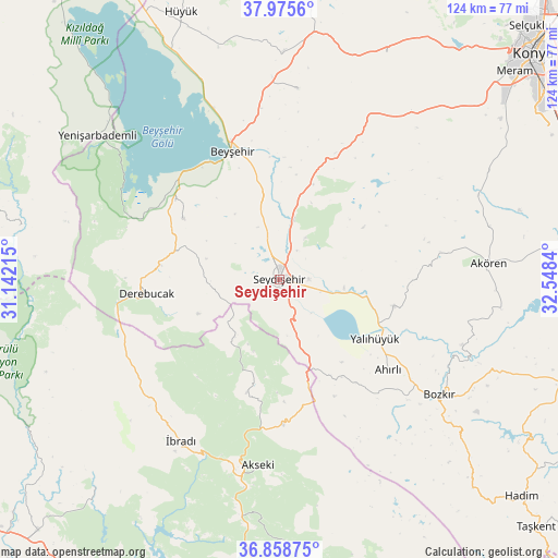
Seydişehir GPS coordinates[2]
37° 25' 9.336" North, 31° 50' 42.972" East
| Map corner | latitude | longitude |
|---|---|---|
| Upper-left | 37.9756°, | 31.14215° |
| Center: | 37.41926°, | 31.84527° |
| Lower-right: | 36.85875°, | 32.5484° |
| Map W x H: | 124.2×124.2 km | = 77.2×77.2mi |
| max Lat: | 42.02683° ⇑77% North |
| Seydişehir: | 37.41926° |
| min Lat: | ⇓23% South 35.9025° |
| min Long | Seydişehir | max Long |
| 25.90902° | 31.84527° | 44.60099° |
| W 32.7%⇐ | ⇒67.3% E |
Elevation
Elevation of Seydişehir is 1127 m = 3698 ft, and this is 409.6 m = 1344 ft above average elevation for this country.
| Max E: |
2682 m = 8799 ft | 23.6% |
| Seydişehir | 1127 m 3698 ft | |
| Avg. | 717.4 m = 2354 ft | |
Min E: |
0 m = 0 ft | 76.4% |
See also: Seydişehir elevation on elevation.city.
Geographical zone
Seydişehir is located in North temperate zone (between Tropic of Cancer and the Arctic Circle). Distance of this Northern Tropic circle is 1554.7 km =966 mi to South.| Distance of | km | miles | from Seydişehir |
|---|---|---|---|
| North Pole | 5846.4 | 3632.8 | to North |
| Arctic Circle | 3240.5 | 2013.6 | to North |
| Tropic Cancer | 1554.7 | 966 | to South |
| Equator | 4160.6 | 2585.3 | to South |


Nearby cities:
15 places around Seydişehir: (largest is in red/bold)
• Ahırlı
31.4 km =19.5 mi,  129°
129°
• Akseki
41.5 km =25.8 mi,  186°
186°
• Akören
46.5 km =28.9 mi,  85°
85°
• Beyşehir
30.6 km =19 mi,  339°
339°
• Bozkır
43.8 km =27.2 mi, 125°
• Cevizli
25.8 km =16 mi,  196°
196°
• Derebucak
29.8 km =18.5 mi,  264°
264°
• Doğanbey
42.6 km =26.5 mi,  5°
5°
• Gencek
26.7 km =16.6 mi,  277°
277°
• Hatunsaray
48.1 km =29.9 mi,  67°
67°
• Yalıhüyük
25 km =15.5 mi,  121°
121°
• Çavuş
22.5 km =14 mi,  19°
19°
• Üzümlü
25.2 km =15.7 mi,  302°
302°
• Üçpınar
48.6 km =30.2 mi, 130°
• İbradı
41.9 km =26 mi,  211°
211°
Sources, notices
• [Note1] Compared only with cities in Turkey existing in our database
• [Src1] Map data: © OpenStreetMap contributors (CC-BY-SA)
• [Src2] Other city data from geonames.org with taken over terms of usage.
• [Src3] Geographical zone / Annual Mean Temperature by Robert A. Rohde @ Wikipedia
