Akseki geodata
Akseki (Antalya) is a seat of a second-order administrative division; located in Turkey in Europe/Istanbul (GMT+3) time zone. With population of 11,616 people, there are 462 cities with bigger population in this country. Compared to other cities in Turkey, 87% of cities are located further ↑North; 67.7% of cities are located further →East and 75% of cities have lower elevation than Akseki. Note1


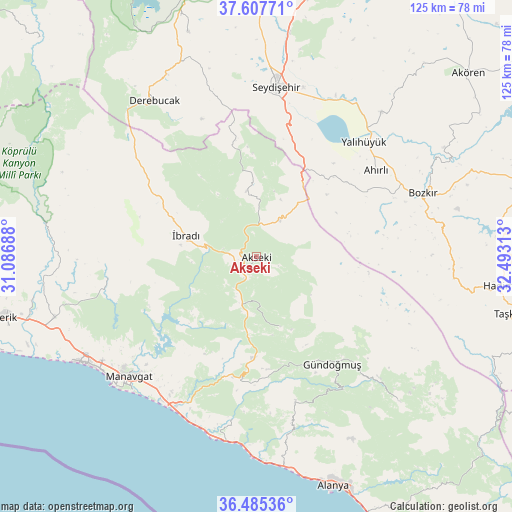
Akseki GPS coordinates[2]
37° 2' 54.996" North, 31° 47' 24" East
| Map corner | latitude | longitude |
|---|---|---|
| Upper-left | 37.60771°, | 31.08688° |
| Center: | 37.04861°, | 31.79° |
| Lower-right: | 36.48536°, | 32.49313° |
| Map W x H: | 124.8×124.8 km | = 77.5×77.5mi |
| max Lat: | 42.02683° ⇑87% North |
| Akseki: | 37.04861° |
| min Lat: | ⇓13% South 35.9025° |
| min Long | Akseki | max Long |
| 25.90902° | 31.79° | 44.60099° |
| W 32.3%⇐ | ⇒67.7% E |
Elevation
Elevation of Akseki is 1105 m = 3625 ft, and this is 387.6 m = 1272 ft above average elevation for this country.
| Max E: |
2682 m = 8799 ft | 25% |
| Akseki | 1105 m 3625 ft | |
| Avg. | 717.4 m = 2354 ft | |
Min E: |
0 m = 0 ft | 75% |
See also: Turkey elevation on elevation.city.
Geographical zone
Akseki is located in North temperate zone (between Tropic of Cancer and the Arctic Circle). Distance of this Northern Tropic circle is 1513.5 km =940.4 mi to South.| Distance of | km | miles | from Akseki |
|---|---|---|---|
| North Pole | 5887.6 | 3658.4 | to North |
| Arctic Circle | 3281.8 | 2039.2 | to North |
| Tropic Cancer | 1513.5 | 940.4 | to South |
| Equator | 4119.4 | 2559.7 | to South |


Nearby cities:
15 places around Akseki: (largest is in red/bold)
• Ahırlı
36 km =22.4 mi,  54°
54°
• Bozkır
43.5 km =27 mi,  68°
68°
• Cevizli
16.7 km =10.4 mi,  351°
351°
• Eksere
32.1 km =19.9 mi,  144°
144°
• Evrenseki
45.1 km =28 mi,  238°
238°
• Geriş
10.8 km =6.7 mi,  207°
207°
• Güzelbağ
36.3 km =22.6 mi,  164°
164°
• Güzelsu
18.1 km =11.2 mi, 160°
• Kızılağaç
42 km =26.1 mi, 212°
• Manavgat
42.4 km =26.3 mi,  226°
226°
• Okurcalar
45.1 km =28 mi,  189°
189°
• Seydişehir
41.5 km =25.8 mi,  6°
6°
• Yalıhüyük
38.4 km =23.9 mi,  43°
43°
• Üçpınar
42.9 km =26.7 mi,  77°
77°
• İbradı
17.8 km =11.1 mi,  287°
287°
Sources, notices
• [Note1] Compared only with cities in Turkey existing in our database
• [Src1] Map data: © OpenStreetMap contributors (CC-BY-SA)
• [Src2] Other city data from geonames.org with taken over terms of usage.
• [Src3] Geographical zone / Annual Mean Temperature by Robert A. Rohde @ Wikipedia
