İbradı geodata
İbradı (Antalya) is a seat of a second-order administrative division; located in Turkey in Europe/Istanbul (GMT+3) time zone. With population of 8,883 people, there are 536 cities with bigger population in this country. Compared to other cities in Turkey, 86.4% of cities are located further ↑North; 68.4% of cities are located further →East and 70.2% of cities have lower elevation than İbradı. Note1


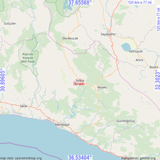
İbradı GPS coordinates[2]
37° 5' 48.984" North, 31° 35' 57.012" East
| Map corner | latitude | longitude |
|---|---|---|
| Upper-left | 37.65568°, | 30.89605° |
| Center: | 37.09694°, | 31.59917° |
| Lower-right: | 36.53404°, | 32.3023° |
| Map W x H: | 124.7×124.7 km | = 77.5×77.5mi |
| max Lat: | 42.02683° ⇑86.4% North |
| İbradı: | 37.09694° |
| min Lat: | ⇓13.6% South 35.9025° |
| min Long | İbradı | max Long |
| 25.90902° | 31.59917° | 44.60099° |
| W 31.6%⇐ | ⇒68.4% E |
Elevation
Elevation of İbradı is 1031 m = 3383 ft, and this is 313.6 m = 1029 ft above average elevation for this country.
| Max E: |
2682 m = 8799 ft | 29.8% |
| İbradı | 1031 m 3383 ft | |
| Avg. | 717.4 m = 2354 ft | |
Min E: |
0 m = 0 ft | 70.2% |
See also: Turkey elevation on elevation.city.
Geographical zone
İbradı is located in North temperate zone (between Tropic of Cancer and the Arctic Circle). Distance of this Northern Tropic circle is 1518.9 km =943.8 mi to South.| Distance of | km | miles | from İbradı |
|---|---|---|---|
| North Pole | 5882.3 | 3655.1 | to North |
| Arctic Circle | 3276.4 | 2035.9 | to North |
| Tropic Cancer | 1518.9 | 943.8 | to South |
| Equator | 4124.8 | 2563 | to South |


Nearby cities:
15 places around İbradı: (largest is in red/bold)
• Akseki
17.8 km =11.1 mi,  107°
107°
• Beşkonak
35.9 km =22.3 mi,  278°
278°
• Boğazkent
47.2 km =29.3 mi,  234°
234°
• Büyükbelkis
42 km =26.1 mi,  246°
246°
• Cevizli
18.3 km =11.4 mi,  52°
52°
• Derebucak
33.7 km =20.9 mi,  346°
346°
• Evrenseki
36 km =22.4 mi,  217°
217°
• Gencek
39.5 km =24.5 mi, 353°
• Geriş
19.1 km =11.9 mi,  141°
141°
• Güzelsu
32.1 km =19.9 mi,  134°
134°
• Kızılağaç
41.1 km =25.5 mi,  187°
187°
• Manavgat
37.2 km =23.1 mi,  201°
201°
• Seydişehir
41.9 km =26 mi,  31°
31°
• Side
41.2 km =25.6 mi,  206°
206°
• Taşağıl
37.6 km =23.4 mi,  238°
238°
Sources, notices
• [Note1] Compared only with cities in Turkey existing in our database
• [Src1] Map data: © OpenStreetMap contributors (CC-BY-SA)
• [Src2] Other city data from geonames.org with taken over terms of usage.
• [Src3] Geographical zone / Annual Mean Temperature by Robert A. Rohde @ Wikipedia
