Çırpı geodata
Çırpı (İzmir) is a seat of a third-order administrative division; located in Turkey in Europe/Istanbul (GMT+3) time zone. In our database, there are 1323 cities with bigger population. Compared to other cities in Turkey, 58.6% of cities are located further ↑North; 93.6% of cities are located further →East and 93.9% of cities have higher elevation than Çırpı. Note1


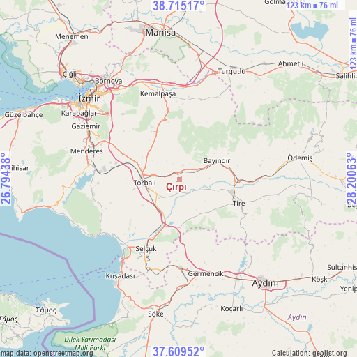
Çırpı GPS coordinates[2]
38° 9' 51.984" North, 27° 29' 51" East
| Map corner | latitude | longitude |
|---|---|---|
| Upper-left | 38.71517°, | 26.79438° |
| Center: | 38.16444°, | 27.4975° |
| Lower-right: | 37.60952°, | 28.20063° |
| Map W x H: | 122.9×122.9 km | = 76.4×76.4mi |
| max Lat: | 42.02683° ⇑58.6% North |
| Çırpı: | 38.16444° |
| min Lat: | ⇓41.4% South 35.9025° |
| min Long | Çırpı | max Long |
| 25.90902° | 27.4975° | 44.60099° |
| W 6.4%⇐ | ⇒93.6% E |
Elevation
Elevation of Çırpı is 21 m = 69 ft, and this is 696.4 m = 2285 ft below average elevation for this country.
| Max E: |
2682 m = 8799 ft | 93.9% |
| Avg. | 717.4 m = 2354 ft | |
| Çırpı | 21 m = 69 ft | |
Min E: |
0 m = 0 ft | 6.1% |
See also: Turkey elevation on elevation.city.
Geographical zone
Çırpı is located in North temperate zone (between Tropic of Cancer and the Arctic Circle). Distance of this Northern Tropic circle is 1637.6 km =1017.6 mi to South.| Distance of | km | miles | from Çırpı |
|---|---|---|---|
| North Pole | 5763.6 | 3581.3 | to North |
| Arctic Circle | 3157.7 | 1962.1 | to North |
| Tropic Cancer | 1637.6 | 1017.6 | to South |
| Equator | 4243.5 | 2636.8 | to South |


Nearby cities:
15 places around Çırpı: (largest is in red/bold)
• Bayındır
14.4 km =8.9 mi,  65°
65°
• Belevi
17.1 km =10.6 mi,  193°
193°
• Boğaziçi
15.4 km =9.6 mi,  159°
159°
• Dağkızılca
18.8 km =11.7 mi,  330°
330°
• Değirmendere
31.7 km =19.7 mi,  259°
259°
• Gaziemir
36.7 km =22.8 mi,  298°
298°
• Germencik
34 km =21.1 mi, 164°
• Gökçen
33.2 km =20.6 mi,  99°
99°
• Kemalpaşa
29.9 km =18.6 mi,  346°
346°
• Menderes
33.1 km =20.6 mi,  286°
286°
• Ortaklar
30.8 km =19.1 mi,  179°
179°
• Selçuk
26.2 km =16.3 mi,  205°
205°
• Tire
22.4 km =13.9 mi,  112°
112°
• Torbalı
11.9 km =7.4 mi, 263°
• Özdere
36.3 km =22.6 mi,  242°
242°
Sources, notices
• [Note1] Compared only with cities in Turkey existing in our database
• [Src1] Map data: © OpenStreetMap contributors (CC-BY-SA)
• [Src2] Other city data from geonames.org with taken over terms of usage.
• [Src3] Geographical zone / Annual Mean Temperature by Robert A. Rohde @ Wikipedia
