Menderes geodata
Menderes (İzmir) is a seat of a second-order administrative division; located in Turkey in Europe/Istanbul (GMT+3) time zone. With population of 21,965 people, there are 311 cities with bigger population in this country. Compared to other cities in Turkey, 57.1% of cities are located further ↑North; 96.1% of cities are located further →East and 79.8% of cities have higher elevation than Menderes. Note1


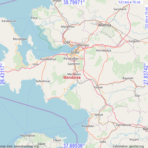
Menderes GPS coordinates[2]
38° 14' 58.668" North, 27° 8' 3.444" East
| Map corner | latitude | longitude |
|---|---|---|
| Upper-left | 38.79971°, | 26.43117° |
| Center: | 38.24963°, | 27.13429° |
| Lower-right: | 37.69536°, | 27.83742° |
| Map W x H: | 122.8×122.8 km | = 76.3×76.3mi |
| max Lat: | 42.02683° ⇑57.1% North |
| Menderes: | 38.24963° |
| min Lat: | ⇓42.9% South 35.9025° |
| min Long | Menderes | max Long |
| 25.90902° | 27.13429° | 44.60099° |
| W 3.9%⇐ | ⇒96.1% E |
Elevation
Elevation of Menderes is 118 m = 387 ft, and this is 599.4 m = 1967 ft below average elevation for this country.
| Max E: |
2682 m = 8799 ft | 79.8% |
| Avg. | 717.4 m = 2354 ft | |
| Menderes | 118 m = 387 ft | |
Min E: |
0 m = 0 ft | 20.2% |
See also: Turkey elevation on elevation.city.
Geographical zone
Menderes is located in North temperate zone (between Tropic of Cancer and the Arctic Circle). Distance of this Northern Tropic circle is 1647 km =1023.4 mi to South.| Distance of | km | miles | from Menderes |
|---|---|---|---|
| North Pole | 5754.1 | 3575.4 | to North |
| Arctic Circle | 3148.2 | 1956.2 | to North |
| Tropic Cancer | 1647 | 1023.4 | to South |
| Equator | 4253 | 2642.7 | to South |


Nearby cities:
15 places around Menderes: (largest is in red/bold)
• Bayraklı
24.3 km =15.1 mi,  6°
6°
• Bornova
27.1 km =16.8 mi,  19°
19°
• Buca
16.8 km =10.4 mi, 9°
• Dağkızılca
23.4 km =14.5 mi,  73°
73°
• Değirmendere
15.1 km =9.4 mi,  177°
177°
• Gaziemir
8.3 km =5.2 mi,  356°
356°
• Karabağlar
13.8 km =8.6 mi,  0°
0°
• Karşıyaka
23.2 km =14.4 mi,  354°
354°
• Kemalpaşa
31.5 km =19.6 mi,  51°
51°
• Seferihisar
26.5 km =16.5 mi,  257°
257°
• Torbalı
22.7 km =14.1 mi,  118°
118°
• Urla
33.3 km =20.7 mi,  284°
284°
• Çırpı
33.1 km =20.6 mi,  106°
106°
• Özdere
26 km =16.2 mi, 181°
• İzmir
18.1 km =11.2 mi, 1°
Sources, notices
• [Note1] Compared only with cities in Turkey existing in our database
• [Src1] Map data: © OpenStreetMap contributors (CC-BY-SA)
• [Src2] Other city data from geonames.org with taken over terms of usage.
• [Src3] Geographical zone / Annual Mean Temperature by Robert A. Rohde @ Wikipedia
