Kemalpaşa geodata
Kemalpaşa (İzmir) is a seat of a second-order administrative division; located in Turkey in Europe/Istanbul (GMT+3) time zone. With population of 30,411 people, there are 250 cities with bigger population in this country. Compared to other cities in Turkey, 53.9% of cities are located further ↑North; 93.9% of cities are located further →East and 73.2% of cities have higher elevation than Kemalpaşa. Note1


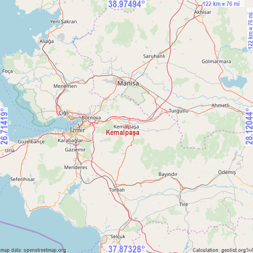
Kemalpaşa GPS coordinates[2]
38° 25' 34.356" North, 27° 25' 2.316" East
| Map corner | latitude | longitude |
|---|---|---|
| Upper-left | 38.97494°, | 26.71419° |
| Center: | 38.42621°, | 27.41731° |
| Lower-right: | 37.87328°, | 28.12044° |
| Map W x H: | 122.5×122.5 km | = 76.1×76.1mi |
| max Lat: | 42.02683° ⇑53.9% North |
| Kemalpaşa: | 38.42621° |
| min Lat: | ⇓46.1% South 35.9025° |
| min Long | Kemalpaşa | max Long |
| 25.90902° | 27.41731° | 44.60099° |
| W 6.1%⇐ | ⇒93.9% E |
Elevation
Elevation of Kemalpaşa is 211 m = 692 ft, and this is 506.4 m = 1661 ft below average elevation for this country.
| Max E: |
2682 m = 8799 ft | 73.2% |
| Avg. | 717.4 m = 2354 ft | |
| Kemalpaşa | 211 m = 692 ft | |
Min E: |
0 m = 0 ft | 26.8% |
See also: Turkey elevation on elevation.city.
Geographical zone
Kemalpaşa is located in North temperate zone (between Tropic of Cancer and the Arctic Circle). Distance of this Northern Tropic circle is 1666.7 km =1035.6 mi to South.| Distance of | km | miles | from Kemalpaşa |
|---|---|---|---|
| North Pole | 5734.5 | 3563.3 | to North |
| Arctic Circle | 3128.6 | 1944 | to North |
| Tropic Cancer | 1666.7 | 1035.6 | to South |
| Equator | 4272.6 | 2654.9 | to South |


Nearby cities:
15 places around Kemalpaşa: (largest is in red/bold)
• Bayraklı
22.5 km =14 mi,  281°
281°
• Bayındır
30.7 km =19.1 mi,  139°
139°
• Bornova
16.5 km =10.3 mi,  290°
290°
• Buca
22.1 km =13.7 mi,  261°
261°
• Dağkızılca
13 km =8.1 mi,  190°
190°
• Gaziemir
27.6 km =17.1 mi,  245°
245°
• Karabağlar
25.3 km =15.7 mi, 256°
• Karaoğlanlı
17.3 km =10.7 mi,  48°
48°
• Karşıyaka
26.9 km =16.7 mi, 277°
• Manisa
20.7 km =12.9 mi,  2°
2°
• Muradiye
26.9 km =16.7 mi,  345°
345°
• Torbalı
30.9 km =19.2 mi, 188°
• Turgutlu
25.8 km =16 mi,  72°
72°
• Çırpı
29.9 km =18.6 mi,  166°
166°
• İzmir
24.3 km =15.1 mi,  266°
266°
Sources, notices
• [Note1] Compared only with cities in Turkey existing in our database
• [Src1] Map data: © OpenStreetMap contributors (CC-BY-SA)
• [Src2] Other city data from geonames.org with taken over terms of usage.
• [Src3] Geographical zone / Annual Mean Temperature by Robert A. Rohde @ Wikipedia
