Gökçen geodata
Gökçen (İzmir) is a seat of a third-order administrative division; located in Turkey in Europe/Istanbul (GMT+3) time zone. With population of 2,499 people, there are 900 cities with bigger population in this country. Compared to other cities in Turkey, 59.5% of cities are located further ↑North; 91% of cities are located further →East and 78.5% of cities have higher elevation than Gökçen. Note1


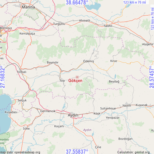
Gökçen GPS coordinates[2]
38° 6' 49.212" North, 27° 52' 17.184" East
| Map corner | latitude | longitude |
|---|---|---|
| Upper-left | 38.66478°, | 27.16832° |
| Center: | 38.11367°, | 27.87144° |
| Lower-right: | 37.55837°, | 28.57457° |
| Map W x H: | 123×123 km | = 76.4×76.4mi |
| max Lat: | 42.02683° ⇑59.5% North |
| Gökçen: | 38.11367° |
| min Lat: | ⇓40.5% South 35.9025° |
| min Long | Gökçen | max Long |
| 25.90902° | 27.87144° | 44.60099° |
| W 9%⇐ | ⇒91% E |
Elevation
Elevation of Gökçen is 132 m = 433 ft, and this is 585.4 m = 1921 ft below average elevation for this country.
| Max E: |
2682 m = 8799 ft | 78.5% |
| Avg. | 717.4 m = 2354 ft | |
| Gökçen | 132 m = 433 ft | |
Min E: |
0 m = 0 ft | 21.5% |
See also: Turkey elevation on elevation.city.
Geographical zone
Gökçen is located in North temperate zone (between Tropic of Cancer and the Arctic Circle). Distance of this Northern Tropic circle is 1631.9 km =1014 mi to South.| Distance of | km | miles | from Gökçen |
|---|---|---|---|
| North Pole | 5769.2 | 3584.8 | to North |
| Arctic Circle | 3163.3 | 1965.6 | to North |
| Tropic Cancer | 1631.9 | 1014 | to South |
| Equator | 4237.8 | 2633.2 | to South |


Nearby cities:
15 places around Gökçen: (largest is in red/bold)
• Aydın
30 km =18.6 mi,  185°
185°
• Bademli
16.7 km =10.4 mi,  102°
102°
• Bayındır
22.7 km =14.1 mi,  300°
300°
• Birgi
22.4 km =13.9 mi,  47°
47°
• Boğaziçi
28.7 km =17.8 mi,  252°
252°
• Kaymakçı
22.2 km =13.8 mi,  74°
74°
• Kiraz
31.9 km =19.8 mi, 65°
• Konaklı
10.9 km =6.8 mi,  90°
90°
• Ovakent
13.1 km =8.1 mi, 93°
• Salavatlı
32 km =19.9 mi,  140°
140°
• Tire
12.2 km =7.6 mi,  256°
256°
• Umurlu
30.4 km =18.9 mi,  164°
164°
• Çaylı
24.2 km =15 mi,  79°
79°
• Ödemiş
15.3 km =9.5 mi,  34°
34°
• İncirliova
31.8 km =19.8 mi,  204°
204°
Sources, notices
• [Note1] Compared only with cities in Turkey existing in our database
• [Src1] Map data: © OpenStreetMap contributors (CC-BY-SA)
• [Src2] Other city data from geonames.org with taken over terms of usage.
• [Src3] Geographical zone / Annual Mean Temperature by Robert A. Rohde @ Wikipedia
