Halfeti geodata
Halfeti (Şanlıurfa) is a seat of a second-order administrative division; located in Turkey in Europe/Istanbul (GMT+3) time zone. With population of 3,261 people, there are 841 cities with bigger population in this country. Compared to other cities in Turkey, 81.9% of cities are located further ↑North; 61% of cities are located further ←West and 65.7% of cities have higher elevation than Halfeti. Note1


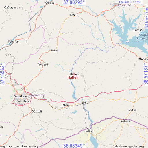
Halfeti GPS coordinates[2]
37° 14' 43.044" North, 37° 52' 7.464" East
| Map corner | latitude | longitude |
|---|---|---|
| Upper-left | 37.80293°, | 37.16562° |
| Center: | 37.24529°, | 37.86874° |
| Lower-right: | 36.68349°, | 38.57187° |
| Map W x H: | 124.5×124.5 km | = 77.4×77.4mi |
| max Lat: | 42.02683° ⇑81.9% North |
| Halfeti: | 37.24529° |
| min Lat: | ⇓18.1% South 35.9025° |
| min Long | Halfeti | max Long |
| 25.90902° | 37.86874° | 44.60099° |
| W 61%⇐ | ⇒39% E |
Elevation
Elevation of Halfeti is 393 m = 1289 ft, and this is 324.4 m = 1064 ft below average elevation for this country.
| Max E: |
2682 m = 8799 ft | 65.7% |
| Avg. | 717.4 m = 2354 ft | |
| Halfeti | 393 m = 1289 ft | |
Min E: |
0 m = 0 ft | 34.3% |
See also: Turkey elevation on elevation.city.
Geographical zone
Halfeti is located in North temperate zone (between Tropic of Cancer and the Arctic Circle). Distance of this Northern Tropic circle is 1535.4 km =954.1 mi to South.| Distance of | km | miles | from Halfeti |
|---|---|---|---|
| North Pole | 5865.8 | 3644.8 | to North |
| Arctic Circle | 3259.9 | 2025.6 | to North |
| Tropic Cancer | 1535.4 | 954.1 | to South |
| Equator | 4141.3 | 2573.3 | to South |


Nearby cities:
15 places around Halfeti: (largest is in red/bold)
• Araban
25.7 km =16 mi,  321°
321°
• Arslanlı
35.3 km =21.9 mi,  144°
144°
• Birecik
26.3 km =16.3 mi,  158°
158°
• Böğürtlen
20.8 km =12.9 mi,  115°
115°
• Elifoğlu
34.9 km =21.7 mi, 162°
• Gevence
37 km =23 mi,  183°
183°
• Kelekli
38.3 km =23.8 mi, 163°
• Keysun
35.1 km =21.8 mi,  358°
358°
• Kızılin
38.2 km =23.7 mi,  28°
28°
• Mağaralı
35.7 km =22.2 mi,  149°
149°
• Nizip
27 km =16.8 mi,  194°
194°
• Sekili
34.4 km =21.4 mi,  210°
210°
• Suvarlı
38.7 km =24 mi,  327°
327°
• Uluyatır
35 km =21.7 mi, 206°
• Yavuzeli
27.8 km =17.3 mi,  286°
286°
Sources, notices
• [Note1] Compared only with cities in Turkey existing in our database
• [Src1] Map data: © OpenStreetMap contributors (CC-BY-SA)
• [Src2] Other city data from geonames.org with taken over terms of usage.
• [Src3] Geographical zone / Annual Mean Temperature by Robert A. Rohde @ Wikipedia
