Bayramiç geodata
Bayramiç (Canakkale) is a seat of a second-order administrative division; located in Turkey in Europe/Istanbul (GMT+3) time zone. In our database, there are 1323 cities with bigger population. Compared to other cities in Turkey, 66% of cities are located further ↓South; 98.8% of cities are located further →East and 81% of cities have higher elevation than Bayramiç. Note1


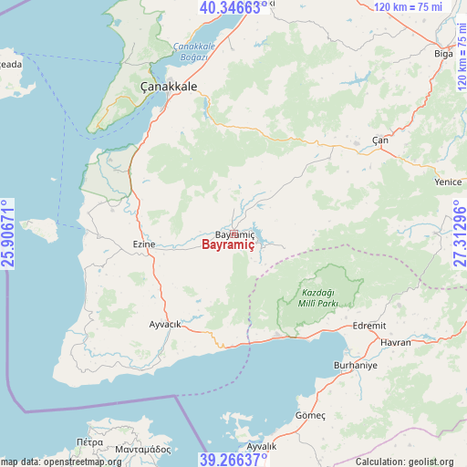
Bayramiç GPS coordinates[2]
39° 48' 31.032" North, 26° 36' 35.388" East
| Map corner | latitude | longitude |
|---|---|---|
| Upper-left | 40.34663°, | 25.90671° |
| Center: | 39.80862°, | 26.60983° |
| Lower-right: | 39.26637°, | 27.31296° |
| Map W x H: | 120.1×120.1 km | = 74.6×74.6mi |
| max Lat: | 42.02683° ⇑34% North |
| Bayramiç: | 39.80862° |
| min Lat: | ⇓66% South 35.9025° |
| min Long | Bayramiç | max Long |
| 25.90902° | 26.60983° | 44.60099° |
| W 1.2%⇐ | ⇒98.8% E |
Elevation
Elevation of Bayramiç is 107 m = 351 ft, and this is 610.4 m = 2003 ft below average elevation for this country.
| Max E: |
2682 m = 8799 ft | 81% |
| Avg. | 717.4 m = 2354 ft | |
| Bayramiç | 107 m = 351 ft | |
Min E: |
0 m = 0 ft | 19% |
See also: Turkey elevation on elevation.city.
Geographical zone
Bayramiç is located in North temperate zone (between Tropic of Cancer and the Arctic Circle). Distance of this Northern Tropic circle is 1820.4 km =1131.1 mi to South.| Distance of | km | miles | from Bayramiç |
|---|---|---|---|
| North Pole | 5580.8 | 3467.7 | to North |
| Arctic Circle | 2974.9 | 1848.5 | to North |
| Tropic Cancer | 1820.4 | 1131.1 | to South |
| Equator | 4426.3 | 2750.4 | to South |


Nearby cities:
15 places around Bayramiç: (largest is in red/bold)
• Altınoluk
27.7 km =17.2 mi,  156°
156°
• Ayvacık
29 km =18 mi,  217°
217°
• Behram
42.3 km =26.3 mi,  214°
214°
• Edremit
42.6 km =26.5 mi,  123°
123°
• Etili
31.4 km =19.5 mi,  51°
51°
• Evciler
14.3 km =8.9 mi,  104°
104°
• Ezine
23.1 km =14.4 mi,  263°
263°
• Geyikli
34.4 km =21.4 mi,  269°
269°
• Kirazlı
27.1 km =16.8 mi,  16°
16°
• Küçükkuyu
28.9 km =18 mi,  180°
180°
• Merkez
39.2 km =24.4 mi,  335°
335°
• Yiğitler
6.5 km =4 mi,  0°
0°
• Çan
45.3 km =28.1 mi,  56°
56°
• Çanakkale
42.1 km =26.2 mi, 336°
• İntepe
32.8 km =20.4 mi,  313°
313°
Sources, notices
• [Note1] Compared only with cities in Turkey existing in our database
• [Src1] Map data: © OpenStreetMap contributors (CC-BY-SA)
• [Src2] Other city data from geonames.org with taken over terms of usage.
• [Src3] Geographical zone / Annual Mean Temperature by Robert A. Rohde @ Wikipedia
