Çanakkale geodata
Çanakkale (Canakkale) is a seat of a first-order administrative division; located in Turkey in Europe/Istanbul (GMT+3) time zone. With population of 87,791 people, there are 103 cities with bigger population in this country. Compared to other cities in Turkey, 71.6% of cities are located further ↓South; 99.3% of cities are located further →East and 96.8% of cities have higher elevation than Çanakkale. Note1


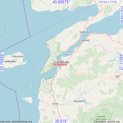
Çanakkale GPS coordinates[2]
40° 9' 19.872" North, 26° 24' 45.756" East
| Map corner | latitude | longitude |
|---|---|---|
| Upper-left | 40.69079°, | 25.70959° |
| Center: | 40.15552°, | 26.41271° |
| Lower-right: | 39.616°, | 27.11584° |
| Map W x H: | 119.5×119.5 km | = 74.3×74.3mi |
| max Lat: | 42.02683° ⇑28.4% North |
| Çanakkale: | 40.15552° |
| min Lat: | ⇓71.6% South 35.9025° |
| min Long | Çanakkale | max Long |
| 25.90902° | 26.41271° | 44.60099° |
| W 0.7%⇐ | ⇒99.3% E |
Elevation
Elevation of Çanakkale is 12 m = 39 ft, and this is 705.4 m = 2314 ft below average elevation for this country.
| Max E: |
2682 m = 8799 ft | 96.8% |
| Avg. | 717.4 m = 2354 ft | |
| Çanakkale | 12 m = 39 ft | |
Min E: |
0 m = 0 ft | 3.2% |
See also: Çanakkale elevation on elevation.city.
Geographical zone
Çanakkale is located in North temperate zone (between Tropic of Cancer and the Arctic Circle). Distance of this Northern Tropic circle is 1859 km =1155.1 mi to South.| Distance of | km | miles | from Çanakkale |
|---|---|---|---|
| North Pole | 5542.2 | 3443.8 | to North |
| Arctic Circle | 2936.3 | 1824.5 | to North |
| Tropic Cancer | 1859 | 1155.1 | to South |
| Equator | 4464.9 | 2774.4 | to South |


Nearby cities:
15 places around Çanakkale: (largest is in red/bold)
• Bayramiç
42.1 km =26.2 mi,  156°
156°
• Beyçayırı
44.8 km =27.8 mi,  75°
75°
• Bozcaada
46.1 km =28.6 mi,  219°
219°
• Eceabat
5.7 km =3.5 mi,  304°
304°
• Etili
45.3 km =28.1 mi,  114°
114°
• Ezine
41.6 km =25.8 mi,  188°
188°
• Gelibolu
35.8 km =22.2 mi,  37°
37°
• Geyikli
42.7 km =26.5 mi,  204°
204°
• Gökçeada
43.1 km =26.8 mi,  276°
276°
• Kirazlı
27.6 km =17.1 mi,  117°
117°
• Lapseki
31.2 km =19.4 mi,  47°
47°
• Merkez
3 km =1.9 mi,  166°
166°
• Umurbey
18.6 km =11.6 mi,  62°
62°
• Yiğitler
36.2 km =22.5 mi,  152°
152°
• İntepe
17.2 km =10.7 mi, 203°
Sources, notices
• [Note1] Compared only with cities in Turkey existing in our database
• [Src1] Map data: © OpenStreetMap contributors (CC-BY-SA)
• [Src2] Other city data from geonames.org with taken over terms of usage.
• [Src3] Geographical zone / Annual Mean Temperature by Robert A. Rohde @ Wikipedia
