Ezine geodata
Ezine (Canakkale) is a seat of a second-order administrative division; located in Turkey in Europe/Istanbul (GMT+3) time zone. With population of 15,677 people, there are 382 cities with bigger population in this country. Compared to other cities in Turkey, 65.3% of cities are located further ↓South; 99.6% of cities are located further →East and 88.2% of cities have higher elevation than Ezine. Note1


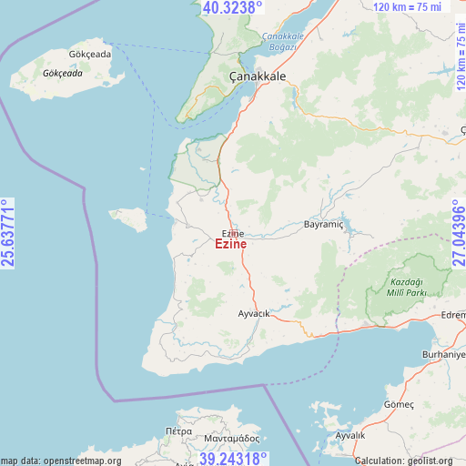
Ezine GPS coordinates[2]
39° 47' 8.196" North, 26° 20' 26.988" East
| Map corner | latitude | longitude |
|---|---|---|
| Upper-left | 40.3238°, | 25.63771° |
| Center: | 39.78561°, | 26.34083° |
| Lower-right: | 39.24318°, | 27.04396° |
| Map W x H: | 120.2×120.2 km | = 74.7×74.7mi |
| max Lat: | 42.02683° ⇑34.7% North |
| Ezine: | 39.78561° |
| min Lat: | ⇓65.3% South 35.9025° |
| min Long | Ezine | max Long |
| 25.90902° | 26.34083° | 44.60099° |
| W 0.4%⇐ | ⇒99.6% E |
Elevation
Elevation of Ezine is 49 m = 161 ft, and this is 668.4 m = 2193 ft below average elevation for this country.
| Max E: |
2682 m = 8799 ft | 88.2% |
| Avg. | 717.4 m = 2354 ft | |
| Ezine | 49 m = 161 ft | |
Min E: |
0 m = 0 ft | 11.8% |
See also: Turkey elevation on elevation.city.
Geographical zone
Ezine is located in North temperate zone (between Tropic of Cancer and the Arctic Circle). Distance of this Northern Tropic circle is 1817.8 km =1129.5 mi to South.| Distance of | km | miles | from Ezine |
|---|---|---|---|
| North Pole | 5583.3 | 3469.3 | to North |
| Arctic Circle | 2977.4 | 1850.1 | to North |
| Tropic Cancer | 1817.8 | 1129.5 | to South |
| Equator | 4423.7 | 2748.8 | to South |


Nearby cities:
15 places around Ezine: (largest is in red/bold)
• Altınoluk
40.9 km =25.4 mi,  124°
124°
• Ayvacık
21.2 km =13.2 mi,  165°
165°
• Bayramiç
23.1 km =14.4 mi,  83°
83°
• Behram
32.5 km =20.2 mi,  181°
181°
• Bozcaada
23.8 km =14.8 mi,  283°
283°
• Eceabat
44.3 km =27.5 mi,  1°
1°
• Evciler
36.8 km =22.9 mi,  91°
91°
• Geyikli
11.6 km =7.2 mi, 280°
• Gülpınar
33.8 km =21 mi,  213°
213°
• Kirazlı
41.9 km =26 mi,  47°
47°
• Küçükkuyu
34.7 km =21.6 mi,  139°
139°
• Merkez
38.8 km =24.1 mi,  10°
10°
• Yiğitler
24.8 km =15.4 mi,  68°
68°
• Çanakkale
41.6 km =25.8 mi, 8°
• İntepe
25.3 km =15.7 mi,  358°
358°
Sources, notices
• [Note1] Compared only with cities in Turkey existing in our database
• [Src1] Map data: © OpenStreetMap contributors (CC-BY-SA)
• [Src2] Other city data from geonames.org with taken over terms of usage.
• [Src3] Geographical zone / Annual Mean Temperature by Robert A. Rohde @ Wikipedia
