Bağarası geodata
Bağarası (Aydın) is a seat of a third-order administrative division; located in Turkey in Europe/Istanbul (GMT+3) time zone. In our database, there are 1323 cities with bigger population. Compared to other cities in Turkey, 70.5% of cities are located further ↑North; 93.3% of cities are located further →East and 93.9% of cities have higher elevation than Bağarası. Note1


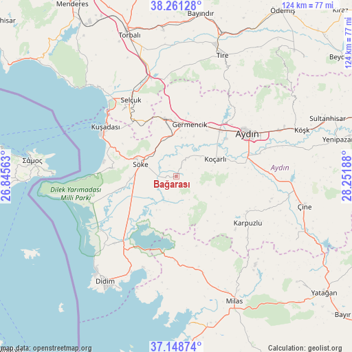
Bağarası GPS coordinates[2]
37° 42' 25.56" North, 27° 32' 55.5" East
| Map corner | latitude | longitude |
|---|---|---|
| Upper-left | 38.26128°, | 26.84563° |
| Center: | 37.7071°, | 27.54875° |
| Lower-right: | 37.14874°, | 28.25188° |
| Map W x H: | 123.7×123.7 km | = 76.9×76.9mi |
| max Lat: | 42.02683° ⇑70.5% North |
| Bağarası: | 37.7071° |
| min Lat: | ⇓29.5% South 35.9025° |
| min Long | Bağarası | max Long |
| 25.90902° | 27.54875° | 44.60099° |
| W 6.7%⇐ | ⇒93.3% E |
Elevation
Elevation of Bağarası is 21 m = 69 ft, and this is 696.4 m = 2285 ft below average elevation for this country.
| Max E: |
2682 m = 8799 ft | 93.9% |
| Avg. | 717.4 m = 2354 ft | |
| Bağarası | 21 m = 69 ft | |
Min E: |
0 m = 0 ft | 6.1% |
See also: Turkey elevation on elevation.city.
Geographical zone
Bağarası is located in North temperate zone (between Tropic of Cancer and the Arctic Circle). Distance of this Northern Tropic circle is 1586.7 km =985.9 mi to South.| Distance of | km | miles | from Bağarası |
|---|---|---|---|
| North Pole | 5814.4 | 3612.9 | to North |
| Arctic Circle | 3208.5 | 1993.7 | to North |
| Tropic Cancer | 1586.7 | 985.9 | to South |
| Equator | 4192.6 | 2605.2 | to South |


Nearby cities:
15 places around Bağarası: (largest is in red/bold)
• Acarlar
21.7 km =13.5 mi,  53°
53°
• Atburgazı
27.8 km =17.3 mi,  253°
253°
• Aydın
29.8 km =18.5 mi,  59°
59°
• Davutlar
22.7 km =14.1 mi,  277°
277°
• Germencik
18.8 km =11.7 mi,  14°
14°
• Karpuzlu
30.2 km =18.8 mi,  123°
123°
• Koçarlı
15.1 km =9.4 mi,  66°
66°
• Kuşadası
30.8 km =19.1 mi,  303°
303°
• Ortaklar
20.5 km =12.7 mi,  348°
348°
• Sarıkemer
22.6 km =14 mi,  226°
226°
• Selçuk
31.4 km =19.5 mi,  329°
329°
• Söke
13.3 km =8.3 mi,  290°
290°
• Tepecik
31.5 km =19.6 mi, 65°
• Çakırbeyli
24.4 km =15.2 mi,  82°
82°
• İncirliova
22.3 km =13.9 mi,  43°
43°
Sources, notices
• [Note1] Compared only with cities in Turkey existing in our database
• [Src1] Map data: © OpenStreetMap contributors (CC-BY-SA)
• [Src2] Other city data from geonames.org with taken over terms of usage.
• [Src3] Geographical zone / Annual Mean Temperature by Robert A. Rohde @ Wikipedia
