Karpuzlu geodata
Karpuzlu (Aydın) is a seat of a second-order administrative division; located in Turkey in Europe/Istanbul (GMT+3) time zone. With population of 2,166 people, there are 926 cities with bigger population in this country. Compared to other cities in Turkey, 73.4% of cities are located further ↑North; 91.5% of cities are located further →East and 81.6% of cities have higher elevation than Karpuzlu. Note1


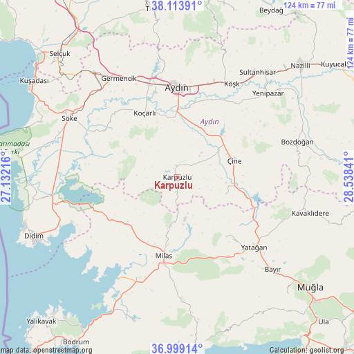
Karpuzlu GPS coordinates[2]
37° 33' 30.996" North, 27° 50' 7.008" East
| Map corner | latitude | longitude |
|---|---|---|
| Upper-left | 38.11391°, | 27.13216° |
| Center: | 37.55861°, | 27.83528° |
| Lower-right: | 36.99914°, | 28.53841° |
| Map W x H: | 124×124 km | = 77.1×77.1mi |
| max Lat: | 42.02683° ⇑73.4% North |
| Karpuzlu: | 37.55861° |
| min Lat: | ⇓26.6% South 35.9025° |
| min Long | Karpuzlu | max Long |
| 25.90902° | 27.83528° | 44.60099° |
| W 8.5%⇐ | ⇒91.5% E |
Elevation
Elevation of Karpuzlu is 99 m = 325 ft, and this is 618.4 m = 2029 ft below average elevation for this country.
| Max E: |
2682 m = 8799 ft | 81.6% |
| Avg. | 717.4 m = 2354 ft | |
| Karpuzlu | 99 m = 325 ft | |
Min E: |
0 m = 0 ft | 18.4% |
See also: Turkey elevation on elevation.city.
Geographical zone
Karpuzlu is located in North temperate zone (between Tropic of Cancer and the Arctic Circle). Distance of this Northern Tropic circle is 1570.2 km =975.7 mi to South.| Distance of | km | miles | from Karpuzlu |
|---|---|---|---|
| North Pole | 5830.9 | 3623.2 | to North |
| Arctic Circle | 3225 | 2003.9 | to North |
| Tropic Cancer | 1570.2 | 975.7 | to South |
| Equator | 4176.1 | 2594.9 | to South |


Nearby cities:
15 places around Karpuzlu: (largest is in red/bold)
• Acarlar
30.6 km =19 mi,  345°
345°
• Akçaova
18 km =11.2 mi,  110°
110°
• Aydın
31.8 km =19.8 mi,  0°
0°
• Bağarası
30.2 km =18.8 mi,  303°
303°
• Dalama
32.8 km =20.4 mi,  38°
38°
• Koçarlı
25.2 km =15.7 mi,  333°
333°
• Milas
27.3 km =17 mi,  189°
189°
• Selimiye
23.7 km =14.7 mi,  222°
222°
• Tepecik
29.7 km =18.5 mi,  6°
6°
• Turgut
26.7 km =16.6 mi,  139°
139°
• Umurlu
34.3 km =21.3 mi,  19°
19°
• Yatağan
36.4 km =22.6 mi,  131°
131°
• Çakırbeyli
19.6 km =12.2 mi,  357°
357°
• Çine
20.6 km =12.8 mi,  73°
73°
• İncirliova
34.1 km =21.2 mi,  343°
343°
Sources, notices
• [Note1] Compared only with cities in Turkey existing in our database
• [Src1] Map data: © OpenStreetMap contributors (CC-BY-SA)
• [Src2] Other city data from geonames.org with taken over terms of usage.
• [Src3] Geographical zone / Annual Mean Temperature by Robert A. Rohde @ Wikipedia
