Koçarlı geodata
Koçarlı (Aydın) is a seat of a second-order administrative division; located in Turkey in Europe/Istanbul (GMT+3) time zone. With population of 8,594 people, there are 550 cities with bigger population in this country. Compared to other cities in Turkey, 69.3% of cities are located further ↑North; 92.2% of cities are located further →East and 90.5% of cities have higher elevation than Koçarlı. Note1


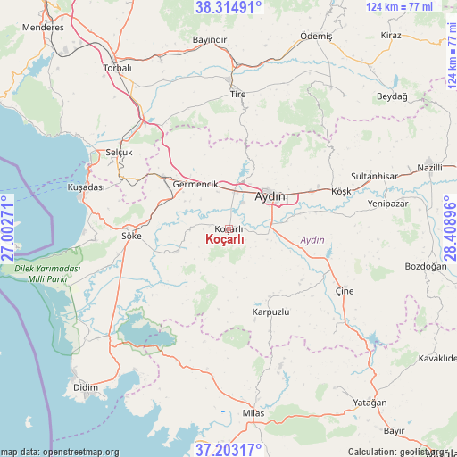
Koçarlı GPS coordinates[2]
37° 45' 40.068" North, 27° 42' 20.988" East
| Map corner | latitude | longitude |
|---|---|---|
| Upper-left | 38.31491°, | 27.00271° |
| Center: | 37.76113°, | 27.70583° |
| Lower-right: | 37.20317°, | 28.40896° |
| Map W x H: | 123.6×123.6 km | = 76.8×76.8mi |
| max Lat: | 42.02683° ⇑69.3% North |
| Koçarlı: | 37.76113° |
| min Lat: | ⇓30.7% South 35.9025° |
| min Long | Koçarlı | max Long |
| 25.90902° | 27.70583° | 44.60099° |
| W 7.8%⇐ | ⇒92.2% E |
Elevation
Elevation of Koçarlı is 37 m = 121 ft, and this is 680.4 m = 2232 ft below average elevation for this country.
| Max E: |
2682 m = 8799 ft | 90.5% |
| Avg. | 717.4 m = 2354 ft | |
| Koçarlı | 37 m = 121 ft | |
Min E: |
0 m = 0 ft | 9.5% |
See also: Turkey elevation on elevation.city.
Geographical zone
Koçarlı is located in North temperate zone (between Tropic of Cancer and the Arctic Circle). Distance of this Northern Tropic circle is 1592.7 km =989.7 mi to South.| Distance of | km | miles | from Koçarlı |
|---|---|---|---|
| North Pole | 5808.4 | 3609.2 | to North |
| Arctic Circle | 3202.5 | 1989.9 | to North |
| Tropic Cancer | 1592.7 | 989.7 | to South |
| Equator | 4198.6 | 2608.9 | to South |


Nearby cities:
15 places around Koçarlı: (largest is in red/bold)
• Acarlar
7.9 km =4.9 mi,  27°
27°
• Aydın
15 km =9.3 mi,  51°
51°
• Bağarası
15.1 km =9.4 mi,  246°
246°
• Boğaziçi
33 km =20.5 mi,  337°
337°
• Dalama
31.9 km =19.8 mi,  84°
84°
• Germencik
15.2 km =9.4 mi,  323°
323°
• Karpuzlu
25.2 km =15.7 mi,  153°
153°
• Köşk
32.1 km =19.9 mi,  71°
71°
• Ortaklar
22.8 km =14.2 mi,  308°
308°
• Söke
26.4 km =16.4 mi,  266°
266°
• Tepecik
16.4 km =10.2 mi,  64°
64°
• Umurlu
24.6 km =15.3 mi, 66°
• Çakırbeyli
10.8 km =6.7 mi,  105°
105°
• Çine
35.2 km =21.9 mi,  117°
117°
• İncirliova
10.2 km =6.3 mi,  8°
8°
Sources, notices
• [Note1] Compared only with cities in Turkey existing in our database
• [Src1] Map data: © OpenStreetMap contributors (CC-BY-SA)
• [Src2] Other city data from geonames.org with taken over terms of usage.
• [Src3] Geographical zone / Annual Mean Temperature by Robert A. Rohde @ Wikipedia
