Cevizpınarı geodata
Cevizpınarı (Mardin) is a populated place; located in Turkey in Europe/Istanbul (GMT+3) time zone. With population of 738 people, there are 1189 cities with bigger population in this country. Compared to other cities in Turkey, 78.4% of cities are located further ↑North; 79.3% of cities are located further ←West and 67.4% of cities have lower elevation than Cevizpınarı. Note1


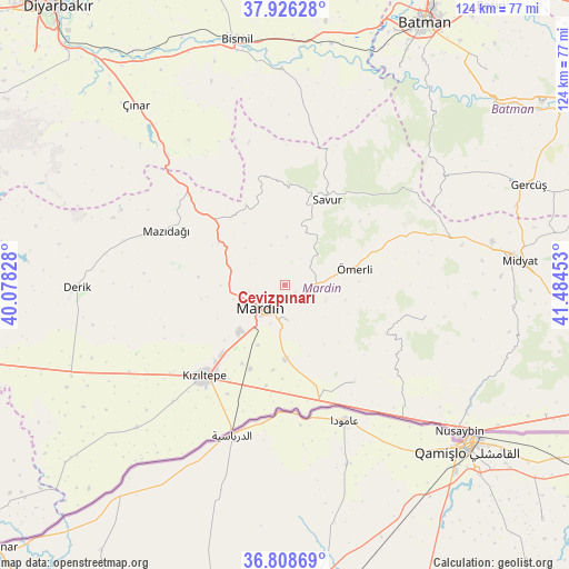
Cevizpınarı GPS coordinates[2]
37° 22' 10.452" North, 40° 46' 53.04" East
| Map corner | latitude | longitude |
|---|---|---|
| Upper-left | 37.92628°, | 40.07828° |
| Center: | 37.36957°, | 40.7814° |
| Lower-right: | 36.80869°, | 41.48453° |
| Map W x H: | 124.3×124.3 km | = 77.2×77.2mi |
| max Lat: | 42.02683° ⇑78.4% North |
| Cevizpınarı: | 37.36957° |
| min Lat: | ⇓21.6% South 35.9025° |
| min Long | Cevizpınarı | max Long |
| 25.90902° | 40.7814° | 44.60099° |
| W 79.3%⇐ | ⇒20.7% E |
Elevation
Elevation of Cevizpınarı is 991 m = 3251 ft, and this is 273.6 m = 898 ft above average elevation for this country.
| Max E: |
2682 m = 8799 ft | 32.6% |
| Cevizpınarı | 991 m 3251 ft | |
| Avg. | 717.4 m = 2354 ft | |
Min E: |
0 m = 0 ft | 67.4% |
See also: Turkey elevation on elevation.city.
Geographical zone
Cevizpınarı is located in North temperate zone (between Tropic of Cancer and the Arctic Circle). Distance of this Northern Tropic circle is 1549.2 km =962.6 mi to South.| Distance of | km | miles | from Cevizpınarı |
|---|---|---|---|
| North Pole | 5852 | 3636.3 | to North |
| Arctic Circle | 3246.1 | 2017 | to North |
| Tropic Cancer | 1549.2 | 962.6 | to South |
| Equator | 4155.1 | 2581.9 | to South |


Nearby cities:
15 places around Cevizpınarı: (largest is in red/bold)
• Aran
9.2 km =5.7 mi,  341°
341°
• Ashagy-Tomik
16.3 km =10.1 mi,  212°
212°
• Dereyanı
9.5 km =5.9 mi,  47°
47°
• Eryeri
8.9 km =5.5 mi,  200°
200°
• Göllü
14.4 km =8.9 mi, 204°
• Kabala
3.1 km =1.9 mi,  147°
147°
• Kaynakkaya
13.8 km =8.6 mi,  103°
103°
• Mardin
7.1 km =4.4 mi, 208°
• Pınardere
12.3 km =7.6 mi,  22°
22°
• Yaylacık
11.3 km =7 mi,  311°
311°
• Yeşilalan
10.1 km =6.3 mi,  1°
1°
• Yeşilli
4.7 km =2.9 mi,  137°
137°
• Yukarı Azıklı
14.8 km =9.2 mi,  218°
218°
• Çınaraltı
7.1 km =4.4 mi,  76°
76°
• Ömerli
15.6 km =9.7 mi, 77°
Sources, notices
• [Note1] Compared only with cities in Turkey existing in our database
• [Src1] Map data: © OpenStreetMap contributors (CC-BY-SA)
• [Src2] Other city data from geonames.org with taken over terms of usage.
• [Src3] Geographical zone / Annual Mean Temperature by Robert A. Rohde @ Wikipedia
