Yeşilalan geodata
Yeşilalan (Mardin) is a populated place; located in Turkey in Europe/Istanbul (GMT+3) time zone. With population of 3,791 people, there are 799 cities with bigger population in this country. Compared to other cities in Turkey, 75.8% of cities are located further ↑North; 79.4% of cities are located further ←West and 65.8% of cities have lower elevation than Yeşilalan. Note1


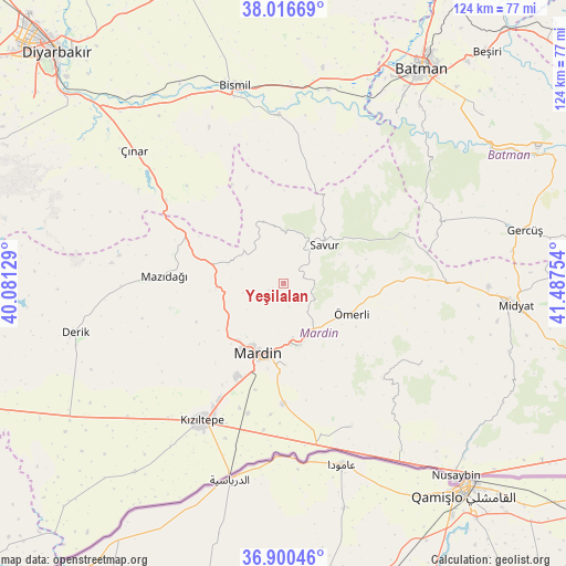
Yeşilalan GPS coordinates[2]
37° 27' 38.376" North, 40° 47' 3.876" East
| Map corner | latitude | longitude |
|---|---|---|
| Upper-left | 38.01669°, | 40.08129° |
| Center: | 37.46066°, | 40.78441° |
| Lower-right: | 36.90046°, | 41.48754° |
| Map W x H: | 124.1×124.1 km | = 77.1×77.1mi |
| max Lat: | 42.02683° ⇑75.8% North |
| Yeşilalan: | 37.46066° |
| min Lat: | ⇓24.2% South 35.9025° |
| min Long | Yeşilalan | max Long |
| 25.90902° | 40.78441° | 44.60099° |
| W 79.4%⇐ | ⇒20.6% E |
Elevation
Elevation of Yeşilalan is 972 m = 3189 ft, and this is 254.6 m = 835 ft above average elevation for this country.
| Max E: |
2682 m = 8799 ft | 34.2% |
| Yeşilalan | 972 m 3189 ft | |
| Avg. | 717.4 m = 2354 ft | |
Min E: |
0 m = 0 ft | 65.8% |
See also: Turkey elevation on elevation.city.
Geographical zone
Yeşilalan is located in North temperate zone (between Tropic of Cancer and the Arctic Circle). Distance of this Northern Tropic circle is 1559.3 km =968.9 mi to South.| Distance of | km | miles | from Yeşilalan |
|---|---|---|---|
| North Pole | 5841.8 | 3629.9 | to North |
| Arctic Circle | 3235.9 | 2010.7 | to North |
| Tropic Cancer | 1559.3 | 968.9 | to South |
| Equator | 4165.2 | 2588.1 | to South |


Nearby cities:
15 places around Yeşilalan: (largest is in red/bold)
• Aran
3.6 km =2.2 mi,  246°
246°
• Avine
13.4 km =8.3 mi,  339°
339°
• Bağlıca
11.4 km =7.1 mi,  310°
310°
• Başkavak
14.7 km =9.1 mi,  38°
38°
• Cevizpınarı
10.1 km =6.3 mi,  181°
181°
• Dereyanı
7.7 km =4.8 mi,  118°
118°
• Kabala
12.8 km =8 mi,  173°
173°
• Kayatepe
14.2 km =8.8 mi,  62°
62°
• Pınardere
4.6 km =2.9 mi,  73°
73°
• Reshidi
16.6 km =10.3 mi,  76°
76°
• Savur
11.8 km =7.3 mi,  45°
45°
• Yaylacık
9.1 km =5.7 mi, 253°
• Yeşilli
13.9 km =8.6 mi, 167°
• Çınaraltı
10.7 km =6.6 mi,  141°
141°
• Ömerli
16.5 km =10.3 mi,  114°
114°
Sources, notices
• [Note1] Compared only with cities in Turkey existing in our database
• [Src1] Map data: © OpenStreetMap contributors (CC-BY-SA)
• [Src2] Other city data from geonames.org with taken over terms of usage.
• [Src3] Geographical zone / Annual Mean Temperature by Robert A. Rohde @ Wikipedia
