Andaç geodata
Andaç (Şırnak) is a populated place; located in Turkey in Europe/Istanbul (GMT+3) time zone. With population of 2,165 people, there are 927 cities with bigger population in this country. Compared to other cities in Turkey, 78.9% of cities are located further ↑North; 97.9% of cities are located further ←West and 85.9% of cities have lower elevation than Andaç. Note1


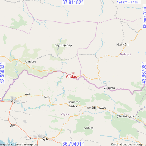
Andaç GPS coordinates[2]
37° 21' 18" North, 43° 15' 50.22" East
| Map corner | latitude | longitude |
|---|---|---|
| Upper-left | 37.91182°, | 42.56083° |
| Center: | 37.355°, | 43.26395° |
| Lower-right: | 36.79401°, | 43.96708° |
| Map W x H: | 124.3×124.3 km | = 77.2×77.2mi |
| max Lat: | 42.02683° ⇑78.9% North |
| Andaç: | 37.355° |
| min Lat: | ⇓21.1% South 35.9025° |
| min Long | Andaç | max Long |
| 25.90902° | 43.26395° | 44.60099° |
| W 97.9%⇐ | ⇒2.1% E |
Elevation
Elevation of Andaç is 1334 m = 4377 ft, and this is 616.6 m = 2023 ft above average elevation for this country.
| Max E: |
2682 m = 8799 ft | 14.1% |
| Andaç | 1334 m 4377 ft | |
| Avg. | 717.4 m = 2354 ft | |
Min E: |
0 m = 0 ft | 85.9% |
See also: Turkey elevation on elevation.city.
Geographical zone
Andaç is located in North temperate zone (between Tropic of Cancer and the Arctic Circle). Distance of this Northern Tropic circle is 1547.6 km =961.6 mi to South.| Distance of | km | miles | from Andaç |
|---|---|---|---|
| North Pole | 5853.6 | 3637.3 | to North |
| Arctic Circle | 3247.7 | 2018 | to North |
| Tropic Cancer | 1547.6 | 961.6 | to South |
| Equator | 4153.5 | 2580.9 | to South |


Nearby cities:
15 places around Andaç: (largest is in red/bold)
• Ashuta
10.4 km =6.5 mi,  110°
110°
• Aşağıdere
21.7 km =13.5 mi,  324°
324°
• Başaran
18 km =11.2 mi, 318°
• Becuh
24.5 km =15.2 mi,  279°
279°
• Beytüşşebap
24.7 km =15.3 mi,  339°
339°
• Bolağaç
25.6 km =15.9 mi,  308°
308°
• Dağdibi
15 km =9.3 mi,  286°
286°
• Karsani
17.6 km =10.9 mi, 107°
• Kelitan
18 km =11.2 mi,  70°
70°
• Ortaköy
3.5 km =2.2 mi,  149°
149°
• Ortasu
27.1 km =16.8 mi,  273°
273°
• Oymakaya
8.1 km =5 mi, 339°
• Pirinçli
27.4 km =17 mi, 312°
• Uzungeçit
28.5 km =17.7 mi,  301°
301°
• Yemişli
16.6 km =10.3 mi, 274°
Sources, notices
• [Note1] Compared only with cities in Turkey existing in our database
• [Src1] Map data: © OpenStreetMap contributors (CC-BY-SA)
• [Src2] Other city data from geonames.org with taken over terms of usage.
• [Src3] Geographical zone / Annual Mean Temperature by Robert A. Rohde @ Wikipedia
