Karsani geodata
Karsani (Hakkâri) is a populated place; located in Turkey in Europe/Istanbul (GMT+3) time zone. With population of 1,323 people, there are 1031 cities with bigger population in this country. Compared to other cities in Turkey, 80.2% of cities are located further ↑North; 98.5% of cities are located further ←West and 79.6% of cities have lower elevation than Karsani. Note1


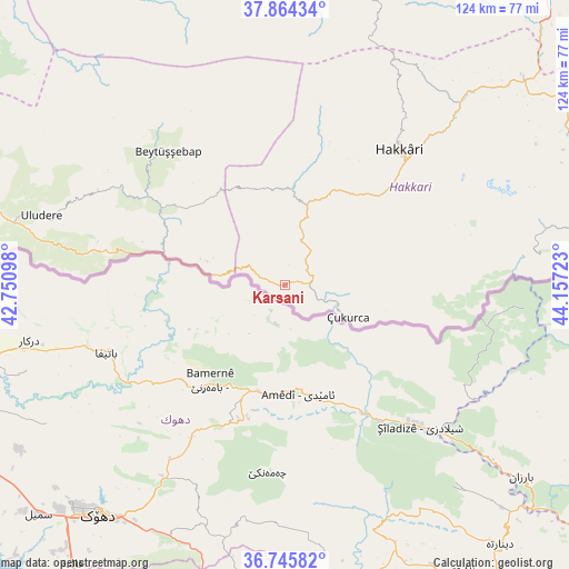
Karsani GPS coordinates[2]
37° 18' 25.776" North, 43° 27' 14.76" East
| Map corner | latitude | longitude |
|---|---|---|
| Upper-left | 37.86434°, | 42.75098° |
| Center: | 37.30716°, | 43.4541° |
| Lower-right: | 36.74582°, | 44.15723° |
| Map W x H: | 124.4×124.4 km | = 77.3×77.3mi |
| max Lat: | 42.02683° ⇑80.2% North |
| Karsani: | 37.30716° |
| min Lat: | ⇓19.8% South 35.9025° |
| min Long | Karsani | max Long |
| 25.90902° | 43.4541° | 44.60099° |
| W 98.5%⇐ | ⇒1.5% E |
Elevation
Elevation of Karsani is 1186 m = 3891 ft, and this is 468.6 m = 1537 ft above average elevation for this country.
| Max E: |
2682 m = 8799 ft | 20.4% |
| Karsani | 1186 m 3891 ft | |
| Avg. | 717.4 m = 2354 ft | |
Min E: |
0 m = 0 ft | 79.6% |
See also: Turkey elevation on elevation.city.
Geographical zone
Karsani is located in North temperate zone (between Tropic of Cancer and the Arctic Circle). Distance of this Northern Tropic circle is 1542.2 km =958.3 mi to South.| Distance of | km | miles | from Karsani |
|---|---|---|---|
| North Pole | 5858.9 | 3640.6 | to North |
| Arctic Circle | 3253 | 2021.3 | to North |
| Tropic Cancer | 1542.2 | 958.3 | to South |
| Equator | 4148.2 | 2577.6 | to South |


Nearby cities:
15 places around Karsani: (largest is in red/bold)
• Andaç
17.6 km =10.9 mi,  287°
287°
• Ashuta
7.2 km =4.5 mi,  284°
284°
• Aşağıdere
37.4 km =23.2 mi,  307°
307°
• Başaran
34.3 km =21.3 mi,  303°
303°
• Becuh
42.1 km =26.2 mi, 282°
• Beytüşşebap
38.2 km =23.7 mi,  318°
318°
• Bolağaç
42.5 km =26.4 mi, 300°
• Dağdibi
32.7 km =20.3 mi, 287°
• Geçitli
32.5 km =20.2 mi,  16°
16°
• Hakkâri
39 km =24.2 mi,  40°
40°
• Kelitan
11.2 km =7 mi,  1°
1°
• Ortaköy
15.2 km =9.4 mi, 278°
• Oymakaya
23.5 km =14.6 mi, 303°
• Yemişli
34 km =21.1 mi, 281°
• Çukurca
15.6 km =9.7 mi,  114°
114°
Sources, notices
• [Note1] Compared only with cities in Turkey existing in our database
• [Src1] Map data: © OpenStreetMap contributors (CC-BY-SA)
• [Src2] Other city data from geonames.org with taken over terms of usage.
• [Src3] Geographical zone / Annual Mean Temperature by Robert A. Rohde @ Wikipedia
