Yağmurlu geodata
Yağmurlu (Şanlıurfa) is a populated place; located in Turkey in Europe/Istanbul (GMT+3) time zone. With population of 517 people, there are 1301 cities with bigger population in this country. Compared to other cities in Turkey, 87.9% of cities are located further ↑North; 70.2% of cities are located further ←West and 55.7% of cities have higher elevation than Yağmurlu. Note1


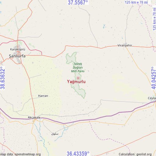
Yağmurlu GPS coordinates[2]
36° 59' 49.992" North, 39° 20' 21.984" East
| Map corner | latitude | longitude |
|---|---|---|
| Upper-left | 37.5567°, | 38.63632° |
| Center: | 36.99722°, | 39.33944° |
| Lower-right: | 36.43359°, | 40.04257° |
| Map W x H: | 124.9×124.9 km | = 77.6×77.6mi |
| max Lat: | 42.02683° ⇑87.9% North |
| Yağmurlu: | 36.99722° |
| min Lat: | ⇓12.1% South 35.9025° |
| min Long | Yağmurlu | max Long |
| 25.90902° | 39.33944° | 44.60099° |
| W 70.2%⇐ | ⇒29.8% E |
Elevation
Elevation of Yağmurlu is 576 m = 1890 ft, and this is 141.4 m = 464 ft below average elevation for this country.
| Max E: |
2682 m = 8799 ft | 55.7% |
| Avg. | 717.4 m = 2354 ft | |
| Yağmurlu | 576 m = 1890 ft | |
Min E: |
0 m = 0 ft | 44.3% |
See also: Turkey elevation on elevation.city.
Geographical zone
Yağmurlu is located in North temperate zone (between Tropic of Cancer and the Arctic Circle). Distance of this Northern Tropic circle is 1507.8 km =936.9 mi to South.| Distance of | km | miles | from Yağmurlu |
|---|---|---|---|
| North Pole | 5893.4 | 3662 | to North |
| Arctic Circle | 3287.5 | 2042.8 | to North |
| Tropic Cancer | 1507.8 | 936.9 | to South |
| Equator | 4113.7 | 2556.1 | to South |


Nearby cities:
15 places around Yağmurlu: (largest is in red/bold)
• Büyük Çaylı
25.1 km =15.6 mi,  133°
133°
• Büyükyıldız
28.3 km =17.6 mi,  143°
143°
• Damlasu
25.1 km =15.6 mi,  160°
160°
• Demirli
29.4 km =18.3 mi,  179°
179°
• Eskiharran
25.9 km =16.1 mi,  253°
253°
• Koyunluca
19.4 km =12.1 mi, 178°
• Meydankapı
28.8 km =17.9 mi,  214°
214°
• Pekmezli
28.8 km =17.9 mi, 160°
• Saide
24.5 km =15.2 mi,  165°
165°
• Seksenören
23.7 km =14.7 mi,  263°
263°
• Selalmaz
27.6 km =17.1 mi,  221°
221°
• Uluağaç
24.7 km =15.3 mi,  226°
226°
• Yolbaşı
15 km =9.3 mi, 126°
• Örenlı
5.9 km =3.7 mi, 247°
• Şuayıpşehri
14.8 km =9.2 mi, 166°
Sources, notices
• [Note1] Compared only with cities in Turkey existing in our database
• [Src1] Map data: © OpenStreetMap contributors (CC-BY-SA)
• [Src2] Other city data from geonames.org with taken over terms of usage.
• [Src3] Geographical zone / Annual Mean Temperature by Robert A. Rohde @ Wikipedia
