Uluağaç geodata
Uluağaç (Şanlıurfa) is a populated place; located in Turkey in Europe/Istanbul (GMT+3) time zone. With population of 612 people, there are 1245 cities with bigger population in this country. Compared to other cities in Turkey, 92.2% of cities are located further ↑North; 68.8% of cities are located further ←West and 66.2% of cities have higher elevation than Uluağaç. Note1


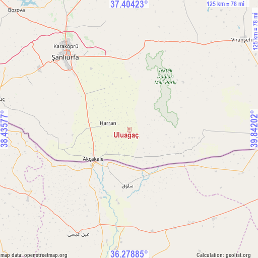
Uluağaç GPS coordinates[2]
36° 50' 36.996" North, 39° 8' 20.004" East
| Map corner | latitude | longitude |
|---|---|---|
| Upper-left | 37.40423°, | 38.43577° |
| Center: | 36.84361°, | 39.13889° |
| Lower-right: | 36.27885°, | 39.84202° |
| Map W x H: | 125.1×125.1 km | = 77.7×77.7mi |
| max Lat: | 42.02683° ⇑92.2% North |
| Uluağaç: | 36.84361° |
| min Lat: | ⇓7.8% South 35.9025° |
| min Long | Uluağaç | max Long |
| 25.90902° | 39.13889° | 44.60099° |
| W 68.8%⇐ | ⇒31.2% E |
Elevation
Elevation of Uluağaç is 385 m = 1263 ft, and this is 332.4 m = 1091 ft below average elevation for this country.
| Max E: |
2682 m = 8799 ft | 66.2% |
| Avg. | 717.4 m = 2354 ft | |
| Uluağaç | 385 m = 1263 ft | |
Min E: |
0 m = 0 ft | 33.8% |
See also: Turkey elevation on elevation.city.
Geographical zone
Uluağaç is located in North temperate zone (between Tropic of Cancer and the Arctic Circle). Distance of this Northern Tropic circle is 1490.7 km =926.3 mi to South.| Distance of | km | miles | from Uluağaç |
|---|---|---|---|
| North Pole | 5910.4 | 3672.6 | to North |
| Arctic Circle | 3304.5 | 2053.3 | to North |
| Tropic Cancer | 1490.7 | 926.3 | to South |
| Equator | 4096.6 | 2545.5 | to South |


Nearby cities:
15 places around Uluağaç: (largest is in red/bold)
• Balkat
13.3 km =8.3 mi,  281°
281°
• Ekinyazı
12.7 km =7.9 mi,  178°
178°
• Eskiharran
12 km =7.5 mi,  324°
324°
• Güneren
13 km =8.1 mi,  200°
200°
• Hacıekber
17.4 km =10.8 mi,  259°
259°
• Harran
9.7 km =6 mi, 280°
• Koyunluca
18.3 km =11.4 mi,  97°
97°
• Küplüce
11 km =6.8 mi,  251°
251°
• Meydankapı
7 km =4.3 mi,  165°
165°
• Minare
15.4 km =9.6 mi,  309°
309°
• Seksenören
15.4 km =9.6 mi,  338°
338°
• Selalmaz
3.6 km =2.2 mi,  187°
187°
• Sugeldi
9.1 km =5.7 mi, 248°
• Tahılalan
14.8 km =9.2 mi,  274°
274°
• Öncül
17.6 km =10.9 mi,  213°
213°
Sources, notices
• [Note1] Compared only with cities in Turkey existing in our database
• [Src1] Map data: © OpenStreetMap contributors (CC-BY-SA)
• [Src2] Other city data from geonames.org with taken over terms of usage.
• [Src3] Geographical zone / Annual Mean Temperature by Robert A. Rohde @ Wikipedia
