Yukarı Karataş geodata
Yukarı Karataş (Şanlıurfa) is a populated place; located in Turkey in Europe/Istanbul (GMT+3) time zone. With population of 904 people, there are 1117 cities with bigger population in this country. Compared to other cities in Turkey, 90.1% of cities are located further ↑North; 73.8% of cities are located further ←West and 66.8% of cities have higher elevation than Yukarı Karataş. Note1


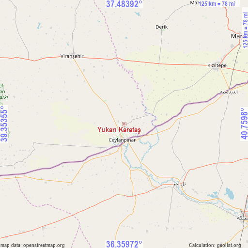
Yukarı Karataş GPS coordinates[2]
36° 55' 26.004" North, 40° 3' 24.012" East
| Map corner | latitude | longitude |
|---|---|---|
| Upper-left | 37.48392°, | 39.35355° |
| Center: | 36.92389°, | 40.05667° |
| Lower-right: | 36.35972°, | 40.7598° |
| Map W x H: | 125×125 km | = 77.7×77.7mi |
| max Lat: | 42.02683° ⇑90.1% North |
| Yukarı Karataş: | 36.92389° |
| min Lat: | ⇓9.9% South 35.9025° |
| min Long | Yukarı Karata� | max Long |
| 25.90902° | 40.05667° | 44.60099° |
| W 73.8%⇐ | ⇒26.2% E |
Elevation
Elevation of Yukarı Karataş is 380 m = 1247 ft, and this is 337.4 m = 1107 ft below average elevation for this country.
| Max E: |
2682 m = 8799 ft | 66.8% |
| Avg. | 717.4 m = 2354 ft | |
| Yukarı Karataş | 380 m = 1247 ft | |
Min E: |
0 m = 0 ft | 33.2% |
See also: Turkey elevation on elevation.city.
Geographical zone
Yukarı Karataş is located in North temperate zone (between Tropic of Cancer and the Arctic Circle). Distance of this Northern Tropic circle is 1499.6 km =931.8 mi to South.| Distance of | km | miles | from Yukarı Karataş |
|---|---|---|---|
| North Pole | 5901.5 | 3667 | to North |
| Arctic Circle | 3295.6 | 2047.8 | to North |
| Tropic Cancer | 1499.6 | 931.8 | to South |
| Equator | 4105.6 | 2551.1 | to South |


Nearby cities:
15 places around Yukarı Karataş: (largest is in red/bold)
• Avcılı
9.9 km =6.2 mi,  85°
85°
• Aydoğdu
8 km =5 mi,  68°
68°
• Aşağıdoruklu
7.1 km =4.4 mi,  110°
110°
• Boğalı
9 km =5.6 mi, 93°
• Büyük Yenice
8.4 km =5.2 mi,  28°
28°
• Ceylanpınar
8.5 km =5.3 mi,  183°
183°
• Damlacık
4.2 km =2.6 mi,  103°
103°
• Hanköy
13 km =8.1 mi,  76°
76°
• Işıklar
10 km =6.2 mi,  38°
38°
• Kocatepe
35.2 km =21.9 mi,  15°
15°
• Muratlı
5.7 km =3.5 mi, 42°
• Viranşehir
42.7 km =26.5 mi,  321°
321°
• Yeşiltepe
13.6 km =8.5 mi, 83°
• Yukarı Taşyalak
8 km =5 mi,  56°
56°
• Çıplak
16.2 km =10.1 mi, 81°
Sources, notices
• [Note1] Compared only with cities in Turkey existing in our database
• [Src1] Map data: © OpenStreetMap contributors (CC-BY-SA)
• [Src2] Other city data from geonames.org with taken over terms of usage.
• [Src3] Geographical zone / Annual Mean Temperature by Robert A. Rohde @ Wikipedia
