Yeşiltepe geodata
Yeşiltepe (Şanlıurfa) is a populated place; located in Turkey in Europe/Istanbul (GMT+3) time zone. With population of 954 people, there are 1099 cities with bigger population in this country. Compared to other cities in Turkey, 89.8% of cities are located further ↑North; 75% of cities are located further ←West and 66.6% of cities have higher elevation than Yeşiltepe. Note1


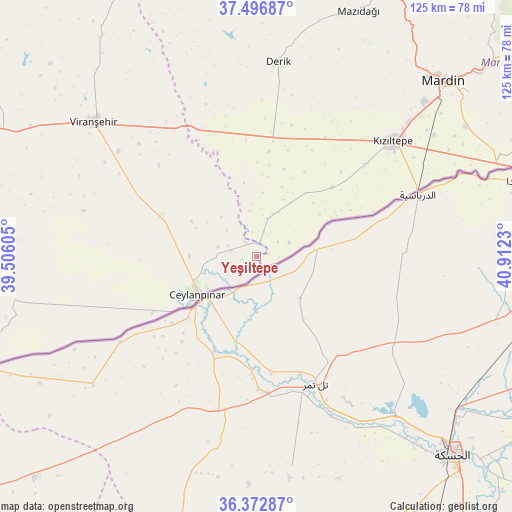
Yeşiltepe GPS coordinates[2]
36° 56' 12.984" North, 40° 12' 33.012" East
| Map corner | latitude | longitude |
|---|---|---|
| Upper-left | 37.49687°, | 39.50605° |
| Center: | 36.93694°, | 40.20917° |
| Lower-right: | 36.37287°, | 40.9123° |
| Map W x H: | 125×125 km | = 77.7×77.7mi |
| max Lat: | 42.02683° ⇑89.8% North |
| Yeşiltepe: | 36.93694° |
| min Lat: | ⇓10.2% South 35.9025° |
| min Long | Yeşiltepe | max Long |
| 25.90902° | 40.20917° | 44.60099° |
| W 75%⇐ | ⇒25% E |
Elevation
Elevation of Yeşiltepe is 381 m = 1250 ft, and this is 336.4 m = 1104 ft below average elevation for this country.
| Max E: |
2682 m = 8799 ft | 66.6% |
| Avg. | 717.4 m = 2354 ft | |
| Yeşiltepe | 381 m = 1250 ft | |
Min E: |
0 m = 0 ft | 33.4% |
See also: Turkey elevation on elevation.city.
Geographical zone
Yeşiltepe is located in North temperate zone (between Tropic of Cancer and the Arctic Circle). Distance of this Northern Tropic circle is 1501.1 km =932.7 mi to South.| Distance of | km | miles | from Yeşiltepe |
|---|---|---|---|
| North Pole | 5900.1 | 3666.2 | to North |
| Arctic Circle | 3294.2 | 2046.9 | to North |
| Tropic Cancer | 1501.1 | 932.7 | to South |
| Equator | 4107 | 2552 | to South |


Nearby cities:
15 places around Yeşiltepe: (largest is in red/bold)
• Avcılı
3.8 km =2.4 mi,  260°
260°
• Aydoğdu
6.3 km =3.9 mi,  283°
283°
• Aşağıdoruklu
8 km =5 mi,  240°
240°
• Boğalı
5 km =3.1 mi,  246°
246°
• Büyük Yenice
11.2 km =7 mi,  301°
301°
• Ceylanpınar
17.3 km =10.7 mi,  234°
234°
• Damlacık
9.8 km =6.1 mi, 255°
• Hanköy
1.8 km =1.1 mi,  328°
328°
• Işıklar
9.7 km =6 mi,  310°
310°
• Kocatepe
32.8 km =20.4 mi,  352°
352°
• Muratlı
10 km =6.2 mi,  285°
285°
• Yaşarköy
33.8 km =21 mi,  61°
61°
• Yukarı Karataş
13.6 km =8.5 mi, 263°
• Yukarı Taşyalak
7.5 km =4.7 mi, 292°
• Çıplak
2.7 km =1.7 mi,  71°
71°
Sources, notices
• [Note1] Compared only with cities in Turkey existing in our database
• [Src1] Map data: © OpenStreetMap contributors (CC-BY-SA)
• [Src2] Other city data from geonames.org with taken over terms of usage.
• [Src3] Geographical zone / Annual Mean Temperature by Robert A. Rohde @ Wikipedia
