Kocatepe geodata
Kocatepe (Mardin) is a seat of a third-order administrative division; located in Turkey in Europe/Istanbul (GMT+3) time zone. In our database, there are 1323 cities with bigger population. Compared to other cities in Turkey, 82.4% of cities are located further ↑North; 74.6% of cities are located further ←West and 61.4% of cities have higher elevation than Kocatepe. Note1


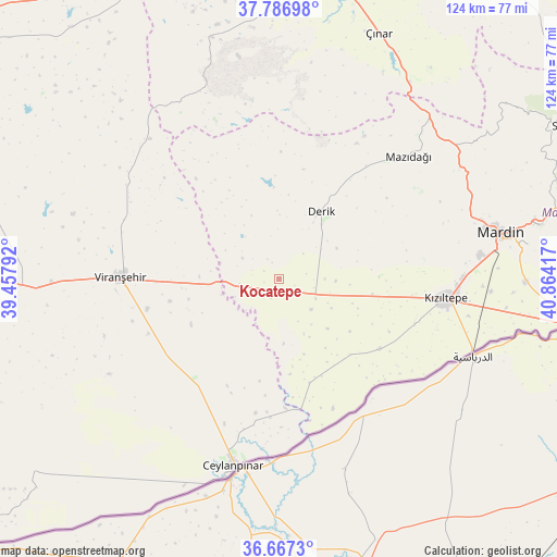
Kocatepe GPS coordinates[2]
37° 13' 45.192" North, 40° 9' 39.744" East
| Map corner | latitude | longitude |
|---|---|---|
| Upper-left | 37.78698°, | 39.45792° |
| Center: | 37.22922°, | 40.16104° |
| Lower-right: | 36.6673°, | 40.86417° |
| Map W x H: | 124.5×124.5 km | = 77.4×77.4mi |
| max Lat: | 42.02683° ⇑82.4% North |
| Kocatepe: | 37.22922° |
| min Lat: | ⇓17.6% South 35.9025° |
| min Long | Kocatepe | max Long |
| 25.90902° | 40.16104° | 44.60099° |
| W 74.6%⇐ | ⇒25.4% E |
Elevation
Elevation of Kocatepe is 487 m = 1598 ft, and this is 230.4 m = 756 ft below average elevation for this country.
| Max E: |
2682 m = 8799 ft | 61.4% |
| Avg. | 717.4 m = 2354 ft | |
| Kocatepe | 487 m = 1598 ft | |
Min E: |
0 m = 0 ft | 38.6% |
See also: Turkey elevation on elevation.city.
Geographical zone
Kocatepe is located in North temperate zone (between Tropic of Cancer and the Arctic Circle). Distance of this Northern Tropic circle is 1533.6 km =952.9 mi to South.| Distance of | km | miles | from Kocatepe |
|---|---|---|---|
| North Pole | 5867.6 | 3646 | to North |
| Arctic Circle | 3261.7 | 2026.7 | to North |
| Tropic Cancer | 1533.6 | 952.9 | to South |
| Equator | 4139.5 | 2572.2 | to South |


Nearby cities:
15 places around Kocatepe: (largest is in red/bold)
• Akziyaret
30.1 km =18.7 mi,  96°
96°
• Avcılı
33.2 km =20.6 mi,  179°
179°
• Aydoğdu
31.1 km =19.3 mi, 183°
• Boğalı
34.5 km =21.4 mi, 180°
• Büyük Yenice
27.1 km =16.8 mi,  191°
191°
• Derik
17.5 km =10.9 mi,  31°
31°
• Gyundyukoru
31.7 km =19.7 mi,  107°
107°
• Hanköy
31.1 km =19.3 mi,  173°
173°
• Işıklar
26.3 km =16.3 mi, 186°
• Karakuyu
34.8 km =21.6 mi, 102°
• Muratlı
30.2 km =18.8 mi, 190°
• Yeşiltepe
32.8 km =20.4 mi, 172°
• Yukarı Karataş
35.2 km =21.9 mi,  195°
195°
• Yukarı Taşyalak
29.7 km =18.5 mi, 184°
• Çıplak
32.4 km =20.1 mi, 167°
Sources, notices
• [Note1] Compared only with cities in Turkey existing in our database
• [Src1] Map data: © OpenStreetMap contributors (CC-BY-SA)
• [Src2] Other city data from geonames.org with taken over terms of usage.
• [Src3] Geographical zone / Annual Mean Temperature by Robert A. Rohde @ Wikipedia
