Karşıyaka geodata
Karşıyaka (Kocaeli) is a populated place; located in Turkey in Europe/Istanbul (GMT+3) time zone. With population of 3,221 people, there are 844 cities with bigger population in this country. Compared to other cities in Turkey, 81% of cities are located further ↓South; 76.2% of cities are located further →East and 80.5% of cities have higher elevation than Karşıyaka. Note1


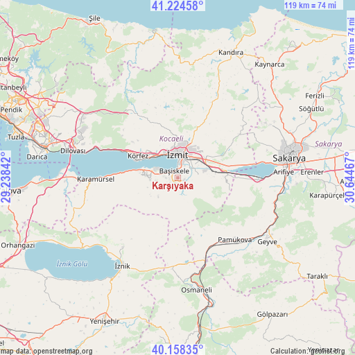
Karşıyaka GPS coordinates[2]
40° 41' 36.96" North, 29° 56' 29.544" East
| Map corner | latitude | longitude |
|---|---|---|
| Upper-left | 41.22458°, | 29.23842° |
| Center: | 40.6936°, | 29.94154° |
| Lower-right: | 40.15835°, | 30.64467° |
| Map W x H: | 118.6×118.6 km | = 73.7×73.7mi |
| max Lat: | 42.02683° ⇑19% North |
| Karşıyaka: | 40.6936° |
| min Lat: | ⇓81% South 35.9025° |
| min Long | Karşıyaka | max Long |
| 25.90902° | 29.94154° | 44.60099° |
| W 23.8%⇐ | ⇒76.2% E |
Elevation
Elevation of Karşıyaka is 112 m = 367 ft, and this is 605.4 m = 1986 ft below average elevation for this country.
| Max E: |
2682 m = 8799 ft | 80.5% |
| Avg. | 717.4 m = 2354 ft | |
| Karşıyaka | 112 m = 367 ft | |
Min E: |
0 m = 0 ft | 19.5% |
See also: Turkey elevation on elevation.city.
Geographical zone
Karşıyaka is located in North temperate zone (between Tropic of Cancer and the Arctic Circle). Distance of this Northern Tropic circle is 1918.8 km =1192.3 mi to South.| Distance of | km | miles | from Karşıyaka |
|---|---|---|---|
| North Pole | 5482.4 | 3406.6 | to North |
| Arctic Circle | 2876.5 | 1787.4 | to North |
| Tropic Cancer | 1918.8 | 1192.3 | to South |
| Equator | 4524.7 | 2811.5 | to South |


Nearby cities:
15 places around Karşıyaka: (largest is in red/bold)
• Bahçecik
3.6 km =2.2 mi,  218°
218°
• Büyükderbent
14.6 km =9.1 mi,  83°
83°
• Derince
12.8 km =8 mi,  303°
303°
• Değirmendere
13.9 km =8.6 mi,  282°
282°
• Elmalı
20.4 km =12.7 mi,  194°
194°
• Gölcük
5.9 km =3.7 mi, 280°
• Halıdere
16.2 km =10.1 mi, 278°
• Kullar
5.3 km =3.3 mi,  49°
49°
• Körfez
15.7 km =9.8 mi, 301°
• Köseköy
7.5 km =4.7 mi, 46°
• Nüzhetiye
8.9 km =5.5 mi,  227°
227°
• Ulaşlı
20.7 km =12.9 mi,  273°
273°
• Yuvacık
2.3 km =1.4 mi,  105°
105°
• İhsaniye
9 km =5.6 mi, 268°
• İzmit
8 km =5 mi,  352°
352°
Sources, notices
• [Note1] Compared only with cities in Turkey existing in our database
• [Src1] Map data: © OpenStreetMap contributors (CC-BY-SA)
• [Src2] Other city data from geonames.org with taken over terms of usage.
• [Src3] Geographical zone / Annual Mean Temperature by Robert A. Rohde @ Wikipedia
