İzmit geodata
İzmit (Kocaeli) is a seat of a first-order administrative division; located in Turkey in Europe/Istanbul (GMT+3) time zone. With population of 196,571 people, there are 52 cities with bigger population in this country. Compared to other cities in Turkey, 82.7% of cities are located further ↓South; 76.2% of cities are located further →East and 82.2% of cities have higher elevation than İzmit. Note1


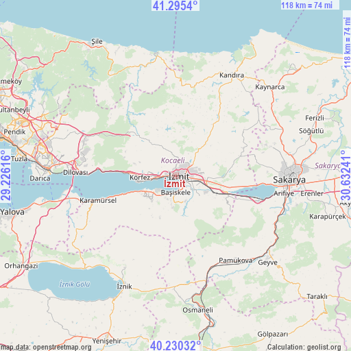
İzmit GPS coordinates[2]
40° 45' 53.964" North, 29° 55' 45.408" East
| Map corner | latitude | longitude |
|---|---|---|
| Upper-left | 41.2954°, | 29.22616° |
| Center: | 40.76499°, | 29.92928° |
| Lower-right: | 40.23032°, | 30.63241° |
| Map W x H: | 118.4×118.4 km | = 73.6×73.6mi |
| max Lat: | 42.02683° ⇑17.3% North |
| İzmit: | 40.76499° |
| min Lat: | ⇓82.7% South 35.9025° |
| min Long | İzmit | max Long |
| 25.90902° | 29.92928° | 44.60099° |
| W 23.8%⇐ | ⇒76.2% E |
Elevation
Elevation of İzmit is 95 m = 312 ft, and this is 622.4 m = 2042 ft below average elevation for this country.
| Max E: |
2682 m = 8799 ft | 82.2% |
| Avg. | 717.4 m = 2354 ft | |
| İzmit | 95 m = 312 ft | |
Min E: |
0 m = 0 ft | 17.8% |
See also: İzmit elevation on elevation.city.
Geographical zone
İzmit is located in North temperate zone (between Tropic of Cancer and the Arctic Circle). Distance of this Northern Tropic circle is 1926.7 km =1197.2 mi to South.| Distance of | km | miles | from İzmit |
|---|---|---|---|
| North Pole | 5474.4 | 3401.6 | to North |
| Arctic Circle | 2868.5 | 1782.4 | to North |
| Tropic Cancer | 1926.7 | 1197.2 | to South |
| Equator | 4532.6 | 2816.4 | to South |


Nearby cities:
15 places around İzmit: (largest is in red/bold)
• Bahçecik
10.8 km =6.7 mi,  186°
186°
• Büyükderbent
16.8 km =10.4 mi,  112°
112°
• Derince
9.7 km =6 mi,  264°
264°
• Değirmendere
13.5 km =8.4 mi,  248°
248°
• Gölcük
8.4 km =5.2 mi,  215°
215°
• Halıdere
15.9 km =9.9 mi, 249°
• Karşıyaka
8 km =5 mi,  172°
172°
• Kullar
6.8 km =4.2 mi,  131°
131°
• Körfez
12.3 km =7.6 mi,  271°
271°
• Köseköy
7 km =4.3 mi, 113°
• Nüzhetiye
15 km =9.3 mi,  201°
201°
• Ulaşlı
20.7 km =12.9 mi, 251°
• Yuvacık
9.1 km =5.7 mi,  159°
159°
• Çat
23.5 km =14.6 mi,  333°
333°
• İhsaniye
11.5 km =7.1 mi, 224°
Sources, notices
• [Note1] Compared only with cities in Turkey existing in our database
• [Src1] Map data: © OpenStreetMap contributors (CC-BY-SA)
• [Src2] Other city data from geonames.org with taken over terms of usage.
• [Src3] Geographical zone / Annual Mean Temperature by Robert A. Rohde @ Wikipedia
