Yoğuntaş geodata
Yoğuntaş (Kırklareli) is a seat of a third-order administrative division; located in Turkey in Europe/Istanbul (GMT+3) time zone. In our database, there are 1323 cities with bigger population. Compared to other cities in Turkey, 99.2% of cities are located further ↓South; 96.7% of cities are located further →East and 68.7% of cities have higher elevation than Yoğuntaş. Note1


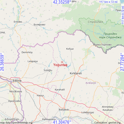
Yoğuntaş GPS coordinates[2]
41° 49' 50.916" North, 27° 4' 10.956" East
| Map corner | latitude | longitude |
|---|---|---|
| Upper-left | 42.35258°, | 26.36659° |
| Center: | 41.83081°, | 27.06971° |
| Lower-right: | 41.30476°, | 27.77284° |
| Map W x H: | 116.5×116.5 km | = 72.4×72.4mi |
| max Lat: | 42.02683° ⇑0.8% North |
| Yoğuntaş: | 41.83081° |
| min Lat: | ⇓99.2% South 35.9025° |
| min Long | Yoğuntaş | max Long |
| 25.90902° | 27.06971° | 44.60099° |
| W 3.3%⇐ | ⇒96.7% E |
Elevation
Elevation of Yoğuntaş is 348 m = 1142 ft, and this is 369.4 m = 1212 ft below average elevation for this country.
| Max E: |
2682 m = 8799 ft | 68.7% |
| Avg. | 717.4 m = 2354 ft | |
| Yoğuntaş | 348 m = 1142 ft | |
Min E: |
0 m = 0 ft | 31.3% |
See also: Turkey elevation on elevation.city.
Geographical zone
Yoğuntaş is located in North temperate zone (between Tropic of Cancer and the Arctic Circle). Distance of this Northern Tropic circle is 2045.2 km =1270.8 mi to South.| Distance of | km | miles | from Yoğuntaş |
|---|---|---|---|
| North Pole | 5355.9 | 3328 | to North |
| Arctic Circle | 2750 | 1708.8 | to North |
| Tropic Cancer | 2045.2 | 1270.8 | to South |
| Equator | 4651.2 | 2890.1 | to South |


Nearby cities:
15 places around Yoğuntaş: (largest is in red/bold)
• Babaeski
44.3 km =27.5 mi,  177°
177°
• Dereköy
27.2 km =16.9 mi,  66°
66°
• Edirne
45.9 km =28.5 mi,  248°
248°
• Hasköy
27.7 km =17.2 mi,  219°
219°
• Havsa
37.5 km =23.3 mi,  213°
213°
• Karakasım
49.7 km =30.9 mi,  225°
225°
• Kofçaz
14.6 km =9.1 mi,  30°
30°
• Kırklareli
16.7 km =10.4 mi,  129°
129°
• Lâlapaşa
27.7 km =17.2 mi,  272°
272°
• Lüleburgaz
53.2 km =33.1 mi,  153°
153°
• Pınarhisar
43.9 km =27.3 mi,  121°
121°
• Süloğlu
14.9 km =9.3 mi,  242°
242°
• Sırpsındığı
49.3 km =30.6 mi,  263°
263°
• Üsküp
29.8 km =18.5 mi,  110°
110°
• İnece
17.1 km =10.6 mi, 180°
Sources, notices
• [Note1] Compared only with cities in Turkey existing in our database
• [Src1] Map data: © OpenStreetMap contributors (CC-BY-SA)
• [Src2] Other city data from geonames.org with taken over terms of usage.
• [Src3] Geographical zone / Annual Mean Temperature by Robert A. Rohde @ Wikipedia
