Süloğlu geodata
Süloğlu (Edirne) is a seat of a second-order administrative division; located in Turkey in Europe/Istanbul (GMT+3) time zone. In our database, there are 1323 cities with bigger population. Compared to other cities in Turkey, 98.9% of cities are located further ↓South; 97.4% of cities are located further →East and 77.3% of cities have higher elevation than Süloğlu. Note1


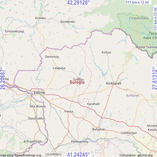
Süloğlu GPS coordinates[2]
41° 46' 8.436" North, 26° 54' 35.964" East
| Map corner | latitude | longitude |
|---|---|---|
| Upper-left | 42.29128°, | 26.20687° |
| Center: | 41.76901°, | 26.90999° |
| Lower-right: | 41.24245°, | 27.61312° |
| Map W x H: | 116.6×116.6 km | = 72.5×72.5mi |
| max Lat: | 42.02683° ⇑1.1% North |
| Süloğlu: | 41.76901° |
| min Lat: | ⇓98.9% South 35.9025° |
| min Long | Süloğlu | max Long |
| 25.90902° | 26.90999° | 44.60099° |
| W 2.6%⇐ | ⇒97.4% E |
Elevation
Elevation of Süloğlu is 148 m = 486 ft, and this is 569.4 m = 1868 ft below average elevation for this country.
| Max E: |
2682 m = 8799 ft | 77.3% |
| Avg. | 717.4 m = 2354 ft | |
| Süloğlu | 148 m = 486 ft | |
Min E: |
0 m = 0 ft | 22.7% |
See also: Turkey elevation on elevation.city.
Geographical zone
Süloğlu is located in North temperate zone (between Tropic of Cancer and the Arctic Circle). Distance of this Northern Tropic circle is 2038.4 km =1266.6 mi to South.| Distance of | km | miles | from Süloğlu |
|---|---|---|---|
| North Pole | 5362.8 | 3332.3 | to North |
| Arctic Circle | 2756.9 | 1713.1 | to North |
| Tropic Cancer | 2038.4 | 1266.6 | to South |
| Equator | 4644.3 | 2885.8 | to South |


Nearby cities:
15 places around Süloğlu: (largest is in red/bold)
• Babaeski
40.4 km =25.1 mi,  157°
157°
• Dereköy
42.1 km =26.2 mi,  64°
64°
• Edirne
31.1 km =19.3 mi,  250°
250°
• Hasköy
15.2 km =9.4 mi,  196°
196°
• Havsa
25.5 km =15.8 mi, 196°
• Karakasım
35.7 km =22.2 mi,  218°
218°
• Kofçaz
28.4 km =17.6 mi,  46°
46°
• Kırcasalih
43.2 km =26.8 mi,  192°
192°
• Kırklareli
26.4 km =16.4 mi,  98°
98°
• Lâlapaşa
16.4 km =10.2 mi,  298°
298°
• Pehlivanköy
46.8 km =29.1 mi,  178°
178°
• Sırpsındığı
35.8 km =22.2 mi,  272°
272°
• Yoğuntaş
14.9 km =9.3 mi, 62°
• Üsküp
41.2 km =25.6 mi, 95°
• İnece
16.6 km =10.3 mi,  127°
127°
Sources, notices
• [Note1] Compared only with cities in Turkey existing in our database
• [Src1] Map data: © OpenStreetMap contributors (CC-BY-SA)
• [Src2] Other city data from geonames.org with taken over terms of usage.
• [Src3] Geographical zone / Annual Mean Temperature by Robert A. Rohde @ Wikipedia
